Boston, Lincolnshire
The name Boston is said to be a contraction of "Saint Botolph's town",[6] "stone" or "tun" (Old English, Old Norse and modern Norwegian for a hamlet or farm; hence the Latin villa Sancti Botulfi "St. Botulf's village").
[6] Similarly, it is often linked to the monastery established by the Saxon monk Botolph at "Icanhoe" on the Witham in AD 654 and destroyed by the Vikings in 870,[6] but this is doubted by modern historians.
[citation needed] The 1086 Domesday Book does not mention Boston by name,[9] but nearby settlements of the tenant-in-chief Count Alan Rufus of Brittany are covered.
The order of importance was the other way round, when the Boston quarter of Skirbeck developed at the head of the Haven, which lies under the present Market Place.
At that stage, The Haven was the tidal part of the stream, now represented by the Stone Bridge Drain (map), which carried the water from the East and West Fens.
The reason for the original development of the town, away from the centre of Skirbeck, was that Boston lay on the point where navigable tidal water was alongside the land route, which used the Devensian terminal moraine ridge at Sibsey, between the upland of East Lindsey and the three routes to the south of Boston: The River Witham seems to have joined The Haven after the flood of September 1014, having abandoned the port of Drayton, on what subsequently became known as Bicker Haven.
[9] Around the same time, the decline of the local guilds[9] and shift towards domestic weaving of English wool (conducted in other areas of the country)[citation needed] led to a near-complete collapse of the town's foreign trade.
At the Dissolution of the Monasteries by Henry VIII during the English Reformation, Boston's Dominican, Franciscan, Carmelite, and Augustinian friaries—erected during the boom years of the 13th and 14th centuries—were all expropriated.
[17] At the same time, work on draining the fens to the west of Boston was begun, a scheme which displeased many whose livelihoods were at risk.
(One of the sources of livelihood obtained from the fen was fowling, supplying ducks and geese for meat and in addition the processing of their feathers and down for use in mattresses and pillows.
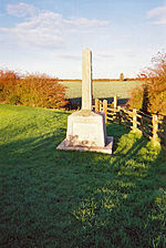
The chief backer of the drainage locally, Lord Lindsey, was shot in the first battle and the fens returned to their accustomed dampness until after 1750.
In 1774, the first financial bank was opened, and in 1776, an act of Parliament allowed watchmen to begin patrolling the streets at night.
Howden developed his business from making steam engines for river boats, while Tuxford began as a miller and millwright.
[citation needed] The railway reached the town in 1848, and it was briefly on the main line from London to the north.
It continued as a working port, exporting grain, fertiliser, and importing timber, although much of the fishing trade was moved out in the interwar period.
[citation needed] At the beginning of the First World War, a number of the town's trawlermen, together with some from Grimsby, were taken prisoner after their ships were sunk by German raiders in the North Sea.
[19] The Haven Bridge, which now carries the two trunk roads over the river, was opened in 1966, and a new dual carriageway, John Adams Way, was built in 1976–8 to take traffic away from the town centre.
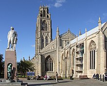
[35] The parish church of Saint Botolph is known locally as Boston Stump and is renowned for its size and its dominant appearance in the surrounding countryside.
The Great Sluice is disguised by railway and road bridges, but it is there, keeping the tide out of the Fens and twice a day, allowing the water from the upland to scour the Haven.
The allegorical figure at the base of the monument is a reference to Ingram's efforts to bring the first piped water to the town.
Born in nearby Paddock Grove, son of a butcher,[37] he was also MP for Boston, from 1856 until his death in 1860, in a shipping accident on Lake Michigan.
[38] The seven-storeyed Maud Foster Tower Windmill, completed in 1819 by millwrights Norman and Smithson of Kingston upon Hull for Issac and Thomas Reckitt, was extensively restored in the late 1980s and became a working mill again.
[40] In Skirbeck Quarter, on the right bank of The Haven, is the Black Sluice, the outfall of the South Forty-Foot Drain.
By tradition, the fair was officially opened by the mayor at midday on 3 May, although this date has varied in recent years.
[42] Blackfriars is a theatre and arts centre[43] that was formerly the refectory of the Benedictine friary, built in the 13th century and once visited by King Edward I. Frampton Marsh and Freiston Shore are two nature reserves, managed by the RSPB, which lie on The Wash coast on either side of the mouth of The Haven.
[44][45] The Boston Preservation Trust has recently extended its Blue Plaque Trail to include a total of 27 examples (as of 2024) of significant heritage to the town and its place in the world.
Phase one consists of a new football ground for Boston United F.C., 500 new homes, retail and business outlets, and a possible supermarket.
Boston United moved out of their former ground, York Street, for the 2020–21 season, to the Jakeman's stadium on the outskirts of town.
[citation needed] After the New Hammond Beck Road Stadium was sold for redevelopment in 1988, attempts to secure a new venue in the 1990s failed.
Established in 2011, it is housed in a Grade II listed building, the former home of the town architect William Wheeler, and caters for the 3–11 year age group.