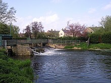
River Welland
The river rises in the Hothorpe Hills, at Sibbertoft in Northamptonshire, then flows generally northeast to Market Harborough, Stamford and Spalding, to reach The Wash near Fosdyke.
The river provided the final outlet to the sea for land drainage schemes implemented in the seventeenth century, although they were not completely successful until a steam-powered pumping station was built at Pode Hole in 1827.
Navigation on the upper river, including the Stamford Canal, had ceased by 1863, but Spalding remained an active port until the end of the Second World War.
Wildlife in the river varies along its length, the faster headwaters being a habitat for trout and the slower lower reaches for perch.
The underlying geology consists of Lias clays at the western end of the catchment, with Lincolnshire limestone in the centre, including the valleys of the Glen.
The Welland rises in the Hothorpe Hills in the parish of Sibbertoft, Northamptonshire and it issues at Spring Croft, Church Street.
[9] One of the driveways to Thorpe Lubenham Hall is carried over the river by an early nineteenth century ashlar bridge which is a Grade II listed structure.
[32] Another pair of early nineteenth-century bridges, built of coursed limestone with ashlar dressings, carry the road over the northernmost channel.
[37] Passing through Spalding, where most of the flow is diverted through the Coronation channel, the town is protected by Marsh Road sluice and a sea lock to the east.
Below the town, it is approached by Vernatt's Drain, which runs parallel to the river carrying water pumped from Deeping Fen, and is crossed by the A16 road bridge.
Nearby is Pinchbeck Marsh Pumping Station, which houses the last beam engine and scoop wheel to be used in the Fens for land drainage.
[39] There are pumping stations for Sea Dike and Lords Drain, and the outfalls of the Risegate Eau and Five Towns drainage channels before the final bridge at Fosdyke is reached.
[41] Richard de Rulos, who was Lord of Deeping Fen during the reign of William the Conqueror erected a strong embankment to prevent flooding of the meadows adjoining the river, which then became fertile fields and a pleasure garden.
[44] In the fourteenth century, Spalding was charged with failing to scour and repair the river, causing damage to the king's liege people, but argued that because it was tidal at this point, it was an arm of the sea, and so they were not responsible.
[47] When built, it was the longest canal with locks in Britain, and was very busy with barges carrying flour, malt, coal, timber and limestone.
The work included making the Welland deeper and wider from Deeping St James to its outfall beyond Spalding, and the construction of side drains.
[50] The river no longer flows through Crowland, but the unique triangular Trinity Bridge, which spanned the junction, remains in the centre of the town.
[57] Hogard devised a scheme to cut a new channel from the junction of the Welland and the Glen to Wyberton, on the estuary of the River Witham below Boston.
[60] Plans to re-route the outfall along a new channel which would meet the River Witham at The Scalp, near Boston, were authorised in 1794, but the money could not be raised at the time, due to the financial crisis caused by the French Wars.
James Walker reported in 1835 on further improvements, making the recommendation that the river below Spalding should be constrained between high banks, so that the scouring action of the water would dredge its own channel.
[63] In 1867, the River Welland Outfall Act enabled the trustees to raise money to repair the walls where the tide had washed away some of the fill behind the fascines.
Towards the end of the Second World War, E. G. Taverner, the chief engineer for the drainage board, devised a plan to relieve flooding in Spalding by creating a bypass channel, and building the Greatford Cut to divert the waters of the West Glen river into the Welland upstream of Market Deeping.
Boats used on the canal were small lighters, around 7 feet (2.1 m) wide, capable of carrying from seven to fourteen tons, and normally worked in trains of four vessels.
[71] There was pressure from merchants to cater for larger vessels, and with later improvements, carried out under an Act of Parliament obtained in 1837, barges and sloops of up to 120 tons could use the port.
Its route is from just off Spalding's High Street upstream along the river, turning onto the Coronation Channel, and going to Springfields Outlet Shopping & Festival Gardens, and back.
[35] Navigation on this stretch was severely restricted by Four Mile Bar footbridge, which provided just 5.25 feet (1.60 m) of headroom, but this was increased when a new single-span arched bridge was installed in early 2007 by the Lincolnshire Waterways Partnership.
[74] Smaller boats such as canoes, which can be carried around obstructions, can continue up to Stamford,[35] but they must use the old course of the river through the Deepings, rather than the Maxey cut.
A variety of birds can be seen, including little grebe and water rail, which spend the winter on the lagoons, while the scrapes, which consist of shallow pools and muddy shorelines, are visited by common redshank and little egret.
Birds of prey such as hen harrier and merlin feed on the flocks of linnet and twite, while the mudflats support dunlin, Eurasian whimbrel, and bar-tailed godwit.
Like most rivers in the UK, the chemical status changed from good to fail in 2019, due to the presence of polybrominated diphenyl ethers (PBDE) and mercury compounds, neither of which had previously been included in the assessment.


