Boundaries of Hong Kong
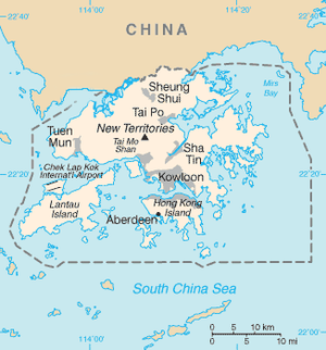
The Boundaries of Hong Kong, officially the Boundary of the Administrative Division of the Hong Kong Special Administrative Region of the People's Republic of China[1][2] (Chinese: 中華人民共和國香港特別行政區行政區域界綫), is a regulated administrative border with border control in force under the One country, two systems constitutional principle, which separates the Hong Kong Special Administrative Region from mainland China, by land border fence of 30 km (19 mi) and maritime boundary of 733 km (455 mi),[1] enforcing a separate immigration and customs-controlled jurisdiction from mainland China.
After the First Opium War and territorial establishment of Hong Kong, the Hong Kong Island was ceded by the Qing Empire to the United Kingdom of Great Britain and Ireland through Treaty of Nanjing in 1842, not marking any official maritime boundaries.
[5] After the Japanese surrender in 1945, all British government institutions in Hong Kong, including the land boundary primarily running across the Sham Chun River were restored.
In April 1949, the British decided to close the border and end the free movement that existed prior.
[8] In 1984, the governments of the United Kingdom and the People's Republic of China (PRC) concluded the Sino-British Joint Declaration on the Question of Hong Kong, under which the sovereignty of the leased territories, together with Hong Kong Island and Kowloon (south of Boundary Street) ceded under the Convention of Peking (1860), was transferred to the PRC on 1 July 1997, maintaining the current land boundary primarily running across the Sham Chun River,[9] however the Hong Kong Basic Law modified and extended the size of Hong Kong's maritime boundary with mainland China in 1997.