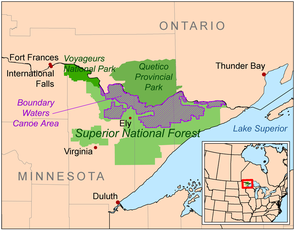
Superior National Forest
The area is part of the greater Boundary Waters region along the border of Minnesota and the Canadian province of Ontario, a historic and important thoroughfare in the fur trading and exploring days of New France and British North America.
High points include the Sawtooth Mountains, a range of hills along the shore of Lake Superior, the Misquah Hills including Eagle Mountain, the state's highest point, and other uplands along the Laurentian Divide separating the watershed of the Great Lakes and Atlantic Ocean from that of Hudson Bay and the Arctic Ocean.
Despite the presence of dramatic cliffs and other local differences in elevation, the area is essentially flat, as it is part of an old peneplain eroded by weathering, water, and especially glaciers.
[1] The principal surficial result of recent glaciation is not the deposition of glacial drift (unlike most of the rest of Minnesota), but the remodeling of the landscape by the scraping away of softer surfaces down to bare hard rock.
The land therefore is raw, with many outcroppings of ancient bedrock, overlain in places by thin layers of gravelly soil and, in the west, silts deposited by Glacial Lake Agassiz.
Tofte Ranger District In January 2023, the Biden administration set a 20-year moratorium on mining in 225,000 acres of the forest that are upstream of the Boundary Waters Canoe Area Wilderness.
The moratorium protects the waters of the Rainy River watershed from pollution and blocks the proposed Twin Metals mine.