Bribie Island
[3] Bribie Island hugs the coastline and tapers to a long spit at its most northern point near Caloundra, and is separated from the mainland by Pumicestone Passage.
The southern end of the island has been intensively urbanised as part of the City of Moreton Bay, the main suburbs being Bongaree, Woorim, Bellara and Banksia Beach.
[4] On 2 January 2022, the ocean broke through the narrow spit of the island 2 km from the northern tip (due to Cyclone Seth culminating with a king tide).
Kangaroos, wallabies, emus, various snake species, green tree frogs and dingos can often be seen venturing from the national park into the surrounding suburbs.
Pumicestone Passage, located between the island and the mainland, is a protected marine park that provides habitat for dugongs, turtles and dolphins.
Flying foxes are important pollinators and seed dispersers while the insect-eating bats help control mosquito and other insect populations.
[10] There is a common misconception that the national park covers most of the non-inhabited area, but in fact most of the centre of the island consists of conifer plantations closed to public access.
The inhabitants of Bribie Island at the time they were encountered by Matthew Flinders in H.M. colonial sloop Norfolk in 1799 were the Djindubari people.
[14] Lieutenant James Cook sighted the Glass House Mountains west of the Island on Thursday 17 May 1770 while sailing up the east coast of Australia in HM Bark Endeavour.
On 16 July 1799 Captain Matthew Flinders left Glass House Bay about two miles (3.2 kilometres) east of the shore in the Norfolk.
He landed on Bribie Island unaware that it wasn't the mainland and met a small group of Aborigines who had gathered on the beach.
Although Bongaree didn't speak the same dialect as the local aborigines the meeting was peaceful until one attempted to remove Flinders' hat.
However, author Libby Connors in her book "Warrior", notes that there was a Joondaburri Elder, from Yarun (Bribie Island) by the name of Bribé, ca 1830.
Tom Archer, Durundur Station owner, wrote of the view of "Briby's Island" from the top of Mt Beerwah in 1841.
[20] Bribie Island fortifications were constructed from 1939 to 1943 as part of the defence of South East Queensland during the Second World War, and to provide artillery training for Australian soldiers.
[21] In February 1939, six months before the start of WW2, a review of the defences of Moreton Bay called for two 6 inch Mark XI guns at north Bribie.
[22] Soon after Australia declared war on Germany on 3 September 1939, 6 inch guns previously carried by the World War I-era cruiser HMAS Sydney were taken to the present location of Fort Bribie (26°51′39″S 153°07′47″E / 26.8609°S 153.1296°E / -26.8609; 153.1296 (6" guns from HMAS Sydney at Fort Bribie))[22] to guard the northwest channel, which ran close to the shore near Caloundra, across the bay in a southeasterly direction towards Moreton Island, and then southwesterly towards the mouth of the river, forming a Z-shaped route.
[21] The mounting and placement of the guns was hopelessly inadequate and according to Major General Robert E Jackson, Officer in Charge of Northern Command in July 1940, Fort Bribie was "no value from a defence point of view" and had to be fixed.
It was argued Caloundra was higher, better equipped and cheaper to build, whereas Bribie was flat, hot, infested with mosquitos and sandflies, had no freshwater, no bridge and would be much more expensive.
[23] Colonel JS Whitelaw designed the layout of the fort on Bribie and recommended its completion, receiving the go ahead by early 1942.
By April—hastened by the December 1941 attacks by the Japanese forces on Pearl Harbor, Malaya, Hong Kong and Singapore—construction of the gun emplacements was almost complete.
[27] It was widely believed at the time that the American and Australian armed forces and governments had conspired on a plan to abandon Australia north of Brisbane to the Japanese in case of invasion.
[33] On 2 January 2022 the ocean broke through the narrow spit of the island 2 km from the northern tip (due to Cyclone Seth culminating with a king tide).
[6] Bribie Island has a number of heritage-listed sites, including: At a Federal level, Bribie Island is part of the Division of Longman and has been represented by Terry Young MP, a member of the Liberal National Party of Queensland who sits in the Liberal party room in parliament, since 2019.
At a state level Bribie Island is represented by Ariana Doolan, the Liberal National Party Member of the Queensland Legislative Assembly for Pumicestone.
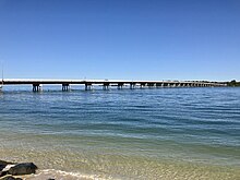
With a length of 2736 feet (831.4 m), the bridge cost £520,000 and was officially opened on Saturday 19 October 1963 by the Premier of Queensland Frank Nicklin.
[citation needed] Bribie Island's main shopping centre is at Bellara, comprising a Woolworths supermarket and a Target store, as well as a number of nationally known companies.
Traditional "strip" development of shopping facilities around the island provides a comprehensive array of retail businesses such as hardware stores, medical centres, newsagents, chemists and food outlets.
In 2004 a reality television series called The Hot House that aired on Network Ten was filmed on Bribie Island.
Nick Earls' 1996 novel After January includes a description of a visit to the beach and the ruins of World War II battlements on the northern end of the island.