Moreton Bay
[3] The waters of Moreton Bay are a popular destination for recreational anglers and are used by commercial operators who provide seafood to market.
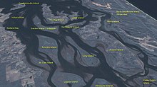
[2] Moreton Bay was formed roughly 6000 years ago as the sea level rose and inundated what was then the floodplains of the Brisbane River.
An 1823 account by explorer John Uniacke described the importance of fish, kangaroo and fern-root called dingowa in the diet of the local tribes.
His paper, titled 'Natives of Moreton Bay' also has a detailed summary of inter-tribal fights in the Bribie Island region, as witnessed by castaways John Finnegan and Thomas Pamphlett.
As the South Passage between Moreton and Stradbroke Islands was the shortest shipping route, a depot and pilot station were established at Amity Point in 1825.
As a result, the facilities required to service the pilot station at Amity grew, and in 1827 convicts were sent to the island to build a new causeway at Dunwich, remnants of which can still be found on the same site.
After the floods had ceased and tides returned to normal, the currents of the bay and sometimes boats were used to delivered the timber north to the Brisbane River or to Dunwich for shipment to Sydney.
[19] The bay was home to the Lightship Rose which provided a permanent navigation aid to passing ships at the mouth of the Brisbane River.
[16] The existence of the quarantine station on Stradbroke Island from 1850 to the 1870s led to the official discouragement of pastoralism or wider settlement for fear of spreading disease.
[15] Thus the European usage and occupation of Quandamooka in the 19th century was largely restricted to government institutions on small portions on the islands, and with free enterprise business men like the Campbell brothers who ran a saltworks and sugar plantations on Russell and Macleay islands, and the early fishing and oystering businesses in the bay who employed the Aboriginal people of Quandamooka.
[26] This relatively shallow depth lets light filter through to the seafloor, allowing an array of marine plants to grow which support a diverse range of fauna.
Western parts of the bay are sometimes tinted green from algae, brown from suspended sediments or yellow-brown from humic runoff.
The Middle Banks area close to Moreton Island has been used in the past as a source of sand for large projects such as the nearby Brisbane Airport and port facilities.
To ensure the shipping channel remains open, several areas of the bay have been allocated for dredged material dumping sites.
The bay's heritage protected wetlands, mudflats, and waterways are some of the healthiest in the region, supporting seasonally up to 25% of Australia's bird species.
The Moreton Bay bug (Thenus orientalis) is a species of slipper lobster found throughout the waters of Australia's north coast.
The southern and western parts of the bay contain shallow mud-layered waters that are protected from strong wave action by the barrier islands.
Climate change is expected to raise sea levels and produce warmer waters that will aid coral growth in the bay.
[44] The eastern shovelnose ray is found in high abundance in Moreton Bay and has an important role in the trophic structure of the area.
[50] Recent increases in sightings along the east coast indicate very slow but certain recovery of the species in that area, and Moreton Bay was probably a prominent calving ground for these coast-loving whales.
[57] Moreton Bay's sea grass beds and corals are subject to ongoing threat from soil run-off caused by agriculture in the Lockyer Valley and construction activity in south east Queensland.
Professor John Olley has noted that mud is now flowing out to Moreton Bay 10 times as fast as it did before Europeans settled in the region 120 years ago.
[58] The 2013 Healthy Waterways Report shows a downward trend in the ecosystem health of Moreton Bay over the period from 2012 to 2013, with water quality also affected by major flood events such as those in 2009 and 2011.
[63] On 13 February 2014 the Government announced that the ASF Consortium's proposal "has demonstrated a cruise ship terminal is a possibility that could be further developed, should the Council and the proponent choose to progress it".
[67] The draft Toondah scheme was opposed by marine planning experts[68] and various environmentally concerned community groups including the Bay Wilderness Society.
Despite angst from both commercial and recreational fishers, draft Queensland Government plans indicate further fishing restrictions aiming to protect more than 15% of important marine and coastal environments.
[76] To make up for the fishing areas lost to the 2009 expansion of the Moreton Bay Marine Park, the Queensland Government agreed to create a total of six artificial reefs for anglers.
[78] In March 2012 the Queensland Government signalled its intention to allow recreational anglers back into marine park green zones in parts of Moreton Bay.
[79] On 31 January 2014 the Queensland Government announced a proposed change to marine park zoning that would relax fishing restrictions at Scotts Point on the Redcliffe Peninsula.
[80] This policy change was criticised by the Australian Marine Conservation Society whose spokesperson said: "We question why Premier Newman is going against the science and the rigorously surveyed opinions of local recreational fishers to adopt a proposal that was being pushed by disgraced former MP Scott Driscoll whilst he was still the member for Redcliffe.