List of bridges in Cambridge
Passing Chesterton, it turns north again and leaves the city, running a further 12 mi (19 km) before merging with the Great Ouse at Pope's Corner to the south of Ely.
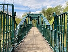
[2] Footbridge linking Coe Fen behind The Leys School over a second small bridge to Lammas Land, near the area known as Hobson's Paradise.
The present wide bridge, clad in Portland stone was designed by Sir Edwin Lutyens in 1932 and built in 1958–9.
The current design is by Timothy Guy Morgan, who at the time was an undergraduate student at Jesus College, after an open competition.
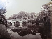
[9] The second oldest of Cambridge's remaining bridges, built by Robert Grumbold (1639–1720) according to designs by Sir Christopher Wren.
[3] The bridge was rebuilt for strengthening in 1992.map 15 Named after the Fort St George pub near its southern end, the site was previously home to a ferry that was "probably the busiest of all the river crossings, running from 8 a.m. to 10 p.m".
The opening caused a few minutes of embarrassment when Lord Butler's golden scissors failed to cut the ribbon across the road.map 18 The bridge forms part of Elizabeth Way (A1134).
[14] map 18a Days afterwards, the northern bank of the bridge became the scene of the first London drugs gang related homicide in Cambridge, with one of the perpetrators being described in court as a victim of modern slavery.
[15] Named after the Green Dragon pub opposite its northern end, the iron-arch bridge was built in 1935, causing the closure of the nearby Horse Grind and Pike & Eel ferries.
Built as part of the 'Cambridge northern bypass', which opened in 1977,[21] the bridge crosses the river just south of Baits Bite Lock.