Bristol Channel
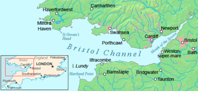
The Bristol Channel (Welsh: Môr Hafren, literal translation: "Severn Sea") is a major inlet in the island of Great Britain, separating South Wales (from Pembrokeshire to the Vale of Glamorgan) and South West England (from Devon, Somerset to North Somerset).
Until Tudor times the Bristol Channel was known as the Severn Sea, and it is still known as this in both Welsh: Môr Hafren and Cornish: Mor Havren.
[1] The International Hydrographic Organization (IHO) defines the offshore western limit of the Bristol Channel as "a line joining Hartland Point in Devon (51°01′N 4°32′W / 51.017°N 4.533°W / 51.017; -4.533) to St. Govan's Head in Pembrokeshire (51°36′N 4°55′W / 51.600°N 4.917°W / 51.600; -4.917)".
[9] Lavernock Point is also used as the boundary between Marine Character Areas 28 and 29, named Bristol Channel and Severn Estuary.
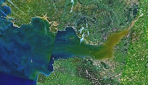
[11][12][13] The Bristol Channel–Severn Estuary system extends eastward inland to the limit of tidal influence, at Gloucester Docks.
Within the channel, however, there is an east–west valley 65–100 ft (20–30 m) deep, which is thought to have been formed by fluvial run-off during Pleistocene phases of lower sea level.
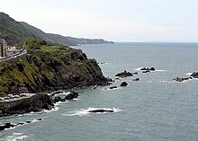
On the Gower Peninsula, at its western extremity is the Worms Head, a headland of Carboniferous Limestone which is approachable on foot at low tide only.
The beaches of Gower (at Rhossili, for example) and North Devon, such as Croyde and Woolacombe, win awards for their water quality and setting, as well as being renowned for surfing.
On the English side, the resort towns of Weston-super-Mare, Burnham-on-Sea, Watchet, Minehead and Ilfracombe are located on the Bristol Channel.
P & A Campbell, based in Bristol, was the main operator of pleasure craft, particularly paddle steamers, from the mid-19th century to the late 1970s, together with the Barry Railway Company.
It has been stated that it would contribute significantly to UK climate change goals and European Union renewable energy targets.
Earlier studies of a possible Severn Barrage included estimates of bed load transport of sand and gravel by tidal ebb and flood that would be interrupted if a solid dam were built across the Channel.
On 30 January 1607 (New style) thousands of people were drowned, houses and villages swept away, farmland inundated and flocks destroyed when a flood hit the shores of the Channel.
There remain plaques up to 8 ft (2.4 m) above sea level to show how high the waters rose on the sides of the surviving churches.
It had long been believed that the floods were caused by a combination of meteorological extremes and tidal peaks, but research published in 2002 showed some evidence of a tsunami in the Channel.
The first known crossing of the Bristol Channel (from Swansea to Woody Bay, near Lynton, Devon) by a windsurfer was Adam Cowles in April 2006,[30] apparently accidentally.
The first person to swim across the Bristol Channel was Kathleen Thomas, a 21-year-old woman from Penarth who swam to Weston-super-Mare on 5 September 1927.
[33][34] The first person to swim the 30.5 nmi (56.5 km; 35.1 mi) from Ilfracombe to Swansea was Gethin Jones, who achieved the record on 13 September 2009, taking nearly 22 hours.
[35] The youngest person to swim from Penarth to Clevedon is Gary Carpenter, who in August 2007 at the age of 17, completed the crossing in 5 hours 35 minutes.