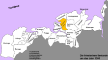
Brokmerland
The Brokmerland is a landscape and historic territory, located in western East Frisia, which covers the area in and around the present-day communities of Brookmerland and Südbrookmerland.
The name comes from the Old Frisian and Old Low German word brōk, which meant a moor-like carr landscape that had been very sparsely settled.
This boundary also played a role in church history because it was the dividing line between the Diocese of Münster (Federgau and Emsgau) and the Archdiocese of Bremen (Norderland and Östringen).
The population grew from about 1100, firstly because the construction of dykes in the region was completed and, secondly, because the "Julian Flood of 1164 forced many people to flee inland from the coast.
As a result of this, the Brokmerland was reclaimed for agriculture by settlers from the Krummhörn Marsh as well as the Norder and Aurich Geest.
From 1251 the Brokmänner then appeared as inhabitants of an independent territory, the Brokmerland, which was initially divided into three intermediate districts, each with two mother churches: Marienhafe and Engerhafe, Wiegsboldsbur and Burhafe (now isolated farms in the Victorbur Marsh), Bedekaspel and Südwolde (Blaukirchen).
The Bishop of Münster acknowledged the growing importance of the area in the middle of the 13th century by granting the church its own diocese.
In addition, the bishop built a castle in Fehnhusen in the parish of Engerhafe, later called the Oldeborg which formed the nucleus of the modern village.
The tom Broks initially tried with some success to establish a territory across Frisia on both sides of the River Ems.
Ocko II finally inherited such a large domain, that he could be titled the Chieftain of East Frisia.
As a result, there was a revolt around 1430 in the Brookmerland (today's spelling), which after an unsuccessful attack by Focko on the town of Bremen by the Lower Weser, spread into a general uprising by the East Frisia people.
[1] In 1440, the Cirksena, then judges and "guardians", became the chieftains of the Brookmerland and Auricherland and had finally begun there, after Ukena's brief reign, the line of the tom Broks.
in 1464, when the Cirksena were elevated to imperial counts, they turned the areas controlled by their castles into districts (Ämter): from then on the Brookmerland, along with the Auricherland, belonged to district (Amt) of Aurich and was divided into the Vogtei of Nordbrookmer, with Osteel, Marienhafe and Siegelsum, and the Vogtei of Südbrookmer with the parishes of Engerhafe, Victorbur, Wiegboldsbur, Bedekaspel, and Forlitz-Blaukirchen.