Brooklyn, Wellington
It lies 3 km south of Wellington's central business district on the eastern slopes of the hills above Happy Valley.
[3] It is located to the south of Aro Valley and Highbury, west of Mount Cook, north of Vogeltown, Mornington and Ōwhiro Bay and east of Kowhai Park, Panorama Heights, Mitcheltown and Karori.
[4]In pre-European times, Māori knew the Brooklyn hills as Turanga-rere, translated as "the waving plumes of the war-party".
[5] The historian James Cowan, in investigating the original Māori names for places in and around Wellington City, suggested this referred to how the tall trees moved in the wind, as "when the warriors stood up to dance... all their feather hair-adornments would wave to and fro".
[6][7] The small Te Atiawa village of Moera, or Moe-i-te-Ra ("Sleeping in the sun") was sited in the area now covered by Maarama Crescent.
In January 1842 the New Zealand Company ship London commanded by Captain Attwood set sail for its second voyage to Wellington from Gravesend in Kent.
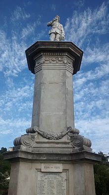
These were then intersected with Reuben, Bruce, Laura and Charlotte Avenues, Tanera Crescent, Apuka Street and Sugar Loaf Road (the site of the War Memorial).
Brooklyn was connected with the city water supply on 24 October 1907, with the pumping station situated on Epuni Street.
Since the 2008 New Zealand general election, the Wellington Central electorate has been represented by Grant Robertson, while Tākuta Ferris has been the Member of Parliament for Te Tai Tonga since 2023.
It is the highest point on Wellington's southern hills and the site of a white radar dome that can be seen from many parts of the city.
The Corporation chose the Brooklyn site due to Wellington's "higher than normal" wind patterns and to gain maximum exposure in the viewshed of Wellingtonians.
Meridian Energy has managed the turbine since its formation as a company in 1999 with the deregulation of the New Zealand electricity market.
[46][47][48] Soon after the war ended in 1918 a movement to build a memorial began, with the funds raised in two years.
[50] For around 16 years, a board of trustees maintained the memorial, before passing it over to Wellington City Council.
The well-preserved Polhill anti-aircraft gun emplacements date from March 1942: built for the capital's defence in response to fears of Japanese air-raids or invasion.
The battery stands slightly north of the wind turbine within Panorama Heights subdivision, on a site allocated as reserve land.
One of the oldest recorded in the general area stands in Nairn Street in the neighbouring suburb of Mount Cook.
[70] Brooklyn hosts the Penthouse Cinema, located on Ohiro Road just south of Cleveland Street.
Constructed for the Ranish family in the art deco style, it opened on 15 June 1939 as the Vogue Theatre.
[73] The Brooklyn Fire Station on Cleveland Street was opened by Sir Māui Pōmare on 10 July 1928.
[74] This replaced the earlier fire service which operated with a handcart and pump, and later a horse and cart, in a building where the Scout Hall now stands on Harrison Street.
[78][79] The Malaysian High Commission occupies the corner of Washington Avenue and Brooklyn Road.
[91] In 2021, a trial bike/scooter lane was installed on the uphill section of Brooklyn hill from Nairn Street to Ohiro Road.
[96][97][98] The head teacher was Mr John Hopkirk and Miss Jessie Fitchett was the infant mistress.
[105] The building remained as one large church hall, installing a temporary partition during the week to create a second classroom.
[105] In 1949 the then Parish Priest Father Paul Kane procured land at the present[update] site on Taft Street.