Brooks Island Regional Preserve
[2] On the island are the remains of several shellmounds left from prolonged occupation by Native Americans, most likely people from the Ohlone tribe, sustained by the abundant sea life in the surrounding bay.
The park district's 1976 resource analysis identified the tribes as "Huchium [Huchiun] or perhaps Chochenyo", and speculated that as many as 15,000 people might have lived on the land over the course of 2,000 to 3,000 years.
[2] From CCo-290, Vera-Mae Fredrickson reported the excavation of two small, elongated, painted pebbles of fine-grained sandstone, one with a single 4mm red band across it, the other with two.
Comparison with other similar painted stones and shells suggested that they might have been used as gaming pieces or dice, or that the two designs might have been intended to symbolize male and female elements.
[3] Over many years of subsequent repairs and extensions, the training wall grew to about 10,000 ft (3,000 m) and siltation built up sand flats of about 30 acres (12 ha) along its length.
[10] Following World War II there were several unrealized plans for the island, including one in the 1950s by the City of Richmond to build a heliport and a causeway from Point Isabel and one by the marine engineering company Ben C. Gerwick, Inc. to flatten the hill in order to facilitate industrial and commercial development.
[2] At the same time, there were unrealized plans for a public park by Contra Costa County (1955) and the state (1956), followed by an attempt by Richmond in 1961 to buy the island for a small boat harbor.
[12] The state purchased the final 16 acres (6.5 ha) private lot on the sand spit in 1985, with a plan for this to be leased to EBRPD.
[12] EBRPD's 1973 master plan designated the site as a regional shoreline and by 1976 a resource analysis for the island had been prepared and presented at two public hearings in Richmond.
[12] This analysis highlighted the value of the island's prehistoric settlements and its natural habitat resources and resulted in a new designation as a regional preserve.
[12] Another hiccup came in 1978 when the land use development plan for the main portion of the island in public ownership was not adopted by EBRPD's board.
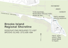
The plan envisaged instituting controlled burns to maintain the balance of grassland and brush, placing a full-time caretaker on the island, using riprap to protect historic sites from erosion, and closing Bird Island and the west end of the sandspit to protect birds' nesting areas.
The mandatory "no project" alternative was seen as degrading the island's habitat over time through increasing shrub growth and subsequent wildfires; the EIR painted a picture of the shooting club then abandoning its lease and vandals looting the shellmounds.
A second alternative encompassing public suggestions such as a restaurant, observation tower or hotel complex was dismissed as obviously more impactful than the district's plan.
The final alternative considered was for EBRPD to sell the island to a private buyer, which was rejected because of the clear conflict with the district's mission.
[18] The sandspit that extends for about two miles west of the main island formed along a breakwater that was installed in the 1920s to preserve a deepwater channel to the Richmond Inner Harbor.
[1][2] During the last ice age San Francisco Bay was a valley, and Brooks Island was just one hill of many along its western slope.
As sea level rose, the valley was flooded and Brooks Island was cut off from the rest of the East Bay.
Domestic mammals including cattle, sheep, goats, horses and dogs were introduced intentionally between the late 18th and mid-20th centuries.
[19][20] House mice (Mus musculus) and Norway rats (Rattus norvegicus) were apparently introduced accidentally during this period.
Although mice were later displaced by voles, Norway rats persist along the island's shores, where they have access to carrion and marine food sources, such as bay mussels (Mytilus trossulus).
In the summer of 1957, seven California voles (Microtus californicus), four males and three females, were introduced to Bird Island with the apparent aim of measuring the population growth rate on an unoccupied land mass.
[23] Today, voles are present throughout Brooks Island, but most notably in the grassland habitat, where the ground is riddled with burrows.
When the sea level rose after the Ice Age, populations of salamanders and garter snakes were marooned on Brooks Island, where they persist today.
The slender salamander (Batrachoseps attenuatus) is found in the north and east of the island, where the soil is damp most of the year.
To the immediate west, Bird Island is a nesting site for Canada geese (Branta canadensis), for which it was the first breeding location in the Bay Area, black oystercatchers (Haematopus bachmani), and western gulls (Larus occidentalis).
Ten percent of the 220 moth and butterfly species recorded on Brooks Island by UC Berkeley entomologist Jerry Powell and colleagues during the period 1993–1997 were either unknown in the San Francisco Bay region or unrecorded for 50 to 100 years.
[28] Because of its limited history of human exploitation, plant communities that are rare elsewhere in the East Bay remain on Brooks Island.
[29] It has been described as a "showcase for coastal grassland, which occurs on the island in a relatively undisturbed state", covering about 18 acres (7.3 ha) of mostly flatter terrain.
Among the grasses are native wildflowers such as blue dicks (Dipterostemon capitatus), soap plant (Chlorogalum parviflorum) and checker mallow (Sidalcea malviflora).