Transportation in the San Francisco Bay Area
People in the San Francisco Bay Area rely on a complex multimodal transportation infrastructure consisting of roads, bridges, highways, rail, tunnels, airports, seaports, and bike and pedestrian paths.
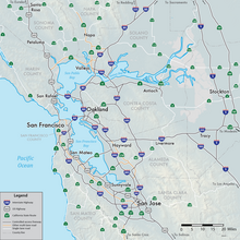
These and other organizations collectively manage several interstate highways and state routes, eight passenger rail networks, eight trans-bay bridges, transbay ferry service, local and transbay bus service, three international airports, and an extensive network of roads, tunnels, and bike paths.
While ferries also connect communities across the bay, most transbay and longer-distance trips on public transportation, however, use rail-based transit.
All major Bay Area airports are located near freeways and are served by public transportation, ride-share services, and various private shuttle bus operators.
An extensive rail infrastructure that provides a mix of services exists within the nine Bay Area counties.
The Bay Area also has two light rail systems: one run by San Francisco Municipal Railway called Muni Metro, which operates within the city of San Francisco, and the other run by the Santa Clara Valley Transportation Authority, which operates within Santa Clara County.
All of these agencies also provide limited late night bus service, which are intended to "shadow" the rail routes that are closed during the nighttime hours for maintenance.
In addition, the four bus agencies are each independently pursuing constructing bus rapid transit systems by developing separated right-of-ways and traffic signaling on busy corridors, including on Geary and Van Ness for Muni, El Camino Real for SamTrans and VTA, and International Boulevard for AC Transit.
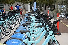
In 2018, several companies started offering dockless scooter-sharing systems in Bay Area cities such as San Francisco and Oakland.
These shared scooters were temporarily banned in San Francisco during summer 2018, but as of October 15, 2018[update] are available under two operators: Skip and Scoot Networks.
[21] The average amount of time people spend commuting with public transit in San Francisco, for example to and from work, on a weekday is 77 min.
Despite this, the San Francisco Bay Area remains the second most traffic-congested region in the country with a declining per capita use of public transit.
During the period starting in 2006 and ending in 2013, the San Francisco MSA had the greatest percentage decline of workers commuting by automobile (3.8 percent) among MSAs with more than a half million residents.
U.S. Route 101 connects to the western terminus of Interstate 80 and provides access to the south of the city along San Francisco Bay toward Silicon Valley.
[citation needed] State Route 1 also enters San Francisco from the north via the Golden Gate Bridge, but turns south away from the routing of U.S. 101, first onto Park Presidio Blvd through Golden Gate Park, and then bisecting the west side of the city as the 19th Avenue arterial thoroughfare, joining with Interstate 280 at the city's southern border.
State Route 82 enters San Francisco from the south as Mission Street, following the path of the historic El Camino Real and terminating shortly thereafter at its junction with 280.
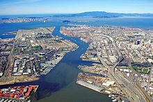
It featured rows of piers perpendicular to the shore, where cargo from the moored ships was handled by cranes and manual labor and transported to nearby warehouses.
The port handled cargo to and from trans-Pacific and Atlantic destinations, and was the West Coast center of the lumber trade.
The 1934 West Coast Longshore Strike, an important episode in the history of the American labor movement, brought most ports to a standstill.
A few active berths specializing in break bulk cargo remain alongside the Islais Creek Channel.
[citation needed] The port currently uses Pier 35 to handle the 60–80 cruise ship calls and 200,000 passengers that come to San Francisco.
Princess will also operate other ships during the summer of 2014, making it the only cruise line home porting year round in San Francisco.