Big Bureau Creek
The bridge, located just north of Interstate 80, is listed on the National Register of Historic Places.
One or both of the brothers ran a trading post near where Big Bureau Creek empties into the Illinois River from 1776 until 1780 or 1790.
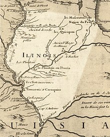
[5][6] The stream was called the Chassagauch", "Chassagoach", or "Chachagouche" River on early maps of the region.
[7][8][9] These are European renderings of the Miami-Illinois language word šaahšaakweehsiiwa, which once meant 'copperhead' (agkistrodon contortrix) but now means 'garter snake'.
[10][11] Šaahšaakweehsiiwa was also the name of a chief and diplomat of the Kaskaskia at the Grand Village of the Illinois, up river from Starved Rock, in the late 17th and early 18th centuries.