Buru
There is little industry on the island, and most population is engaged in growing rice, maize, sweet potato, beans, coconuts, cocoa, coffee, clove and nutmeg.
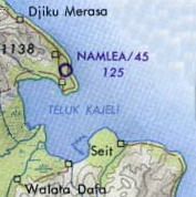
The Dutch administration relocated many local villages to the newly built island capital at Kayeli Bay for working at clove plantations.
[2][3] The highest point on the island (2,700 m (8,900 ft)[4]) is the peak of Mount Kapalatmada (also called Kepala Madan,[2] Kepalat Mada or Ghegan[5]).
It flows nearly straight to the north-east and empties into Kayeli Bay; however, its bed is very winding for hundreds of meters, with loops all along its length.
Among those, the rufous-throated white-eye is regarded as endangered and the black-lored parrot and vulnerable (threatened) by the International Union for Conservation of Nature; both species were observed only in very limited areas of Buru island.
There are another 19 birds that are near-endemic to Buru: rufous-necked sparrowhawk (Accipiter erythrauchen), dusky megapode (Megapodius forstenii), Moluccan megapode (Megapodius wallacei), white-eyed imperial pigeon (Ducula perspicillata), long-tailed mountain pigeon (Gymnophaps mada), red lory (Eos bornea), Moluccan hawk-owl (Ninox squamipila), Moluccan masked owl (Tyto sororcula), Wakolo myzomela (Myzomela wakoloensis), Buru friarbird (Philemon moluccensis), drab whistler (Pachycephala griseonota), white-naped monarch (Monarcha pileatus), dark-grey flycatcher (Myiagra galeata), black-eared oriole (Oriolus bouroensis), pale cicadabird (Coracina ceramensis), Buru thrush (Zoothera dumasi), cinnamon-chested flycatcher (Ficedula buruensis), Buru bush warbler (Locustella disturbans) and Buru flowerpecker (Dicaeum erythrothorax).
The northwestern part of the island has steep limestone cliffs covered by mixed forests that include Shorea trees, and stunted Dacrydium novo-guineense is present at the mountain tops.
[27][28][29] One of the first mentions of Buru occurred in the Nagarakretagama – an Old Javanese eulogy to Hayam Wuruk, the ruler of the Majapahit Kingdom, dating back to 1365.
More active were Makassar people from Sulawesi island, who had built fortifications on Buru and forced the natives to grow valuable spices, such as clove.
[25] They returned after several years and raised a fortress armed with four cannon and staffed by 24 soldiers in 1658 at the southern coast of Kayeli Bay, in the eastern part of Buru.
About 2,000 native inhabitants of the island were forcibly relocated to this area from other parts of the island, including much of the tribal nobility, and about thirteen large villages were built around the fort: Lumaite, Hukumina, Palamata, Tomahu, Masarete, Waisama, Marulat, Leliali, Tagalisa, Ilat, Kayeli, Bara and Lisela.
The relocation was designed to facilitate control over the local population and provide a workforce for clove fields which were being planted by the Dutch in this part of the island.
The Kayeli ethnicity with its own language was formed as a mixture of the newly arriving settlers and the native population of the fort area.
[25] The presence among the ancestors of the tribal aristocracy and interaction with the Dutch colonial administration resulted in a special position for the Kayeli over the next centuries, who claimed the role of indigenous elite of the island.
In particularly, they requested donations from each clan of Buru, which could be rice, millet, coconuts, sago, sweet potatoes and tobacco, as well as supplying men to work exclusively for the Kayeli rajas.
[25] In 1824, as part of the reform of the colonial administration, Buru was divided into 14 regencies (this number was gradually reduced to seven over the next 100 years).
[25][32] The demise of Kayeli dominance began in the 1880s, when the leaders of Leliali, Wae Sama and Fogi clans moved significant parts of their ethnic groups to their original settlements; they were joined in the early 1900s by Tagalisa.
During this period, the island was raided by the bombers of the Allies aiming to incapacitate the Japanese military infrastructure, in particular the airport at Namlea, the major town of Buru.
In December 1946, Buru, along with the other Maluku Islands, Sulawesi and Lesser Sunda Islands, was included in a quasi-independent State of East Indonesia (Indonesian: Negara Indonesia Timur) which was established by the Dutch government to gradually transform their former colonial possessions in the East Indies into a dependent state.
[34][35][36] In April 1950, just before the abolition of RIS and inclusion of most of eastern Indonesia to the Republic of Indonesia, the local authorities of Buru, Ambon, Seram and several smaller nearby islands proclaimed the establishment of an independent Republic of South Moluccas (Indonesian: Republik Maluku Selatan, RMS) and committed to maintain close political ties with the Netherlands.
[34][35] After unsuccessful attempts to absorb the RMS through negotiations, the Republic of Indonesia initiated a six-month military conflict in July 1950.
The growth resumed in the early 2000s,[43] however, unemployment remains high (9.92% of the population in 2008), and more than 37% of islanders are living below the national poverty line (as of 2008[update]).
[43] The major crop is rice with plantations taking an area of more than 5,700 hectares and yielding about 23,000 tonnes per the year (for 2008) in just Buru Regency.
[45] With the total area of 135 hectares, maize dominates the southern field of districts Waisama, Kepalamadan and Namrole, yielding 176 tonnes per year (as of 2008[update]).
[51] In January 2010, the Ministry of Industry of Indonesia has approved a plan to build major cement plants on the island.
[22][43] Apart from agriculture and engineering, other significant economic areas are trade, hotel industry and catering (19.19% of GDP in 2008), custom services (12.74%), transport and communication (3.10%), construction (3.13%), financial sector (2.64%) and energy and water (0.49%).
[53] Speedboats "Bahari Express" run daily between Namlea and the capital of Maluku Province, Ambon (distance 160 km, travel time three hours).
[56] Whereas local people traditionally occupied villages, variation of their seasonal activities – predominantly hunting and farming – tended to either disperse or gather them.
Cement, metal and tiles were introduced in the 20th century and urged to build more permanent dwelling, but with limited results, as the locals continued to relocate.
[25] The unique flora, fauna and tropical forest ecosystem of the island are systematically researched by both Indonesian and foreign scientific bodies.