Busto Arsizio
Despite some claims about a Celtic heritage, recent studies suggest that the "Bustocchi"'s ancestors were Ligurians, called "wild" by Pliny, "marauders and robbers" by Livy and "unshaven and hairy" by Pompeius Tragus.
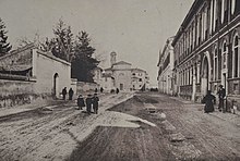
Busto Arsizio continued to grow over the next century, absorbing the nearby communities of Borsano and Sacconago in 1927 in a major administrative reform implemented by the Fascist regime and was only marginally damaged even by World War II (a single Allied airdropped bomb is said to have hit the train station).
The Italian resistance movement resorted preferably to strikes and sabotage than to overt guerrilla warfare, since those willing to fight mostly took to the Ossola mountains, but strengthened in time, suffering grievous losses to arrests, tortures and deportation to the Nazi lager system.
On 25 April 1945, when the partisans took over, Busto Arsizio gave voice to the first free radio channel in northern Italy since the advent of Fascism, at the Church of St. Edward, thanks to Don Ambrogio Gianotti.
After the war, Busto Arsizio turned increasingly on the right of the political spectrum as its bigger industries in the 1960s and 1970s decayed, to be replaced by many familiar small enterprises and a new service-based economy.
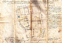
[6] The name of the municipal road known as Strada di S. Alò is found in the 1857 Land Register and corresponds to the current Via Federico Confalonieri, which runs westwards from Piazza Alessandro Manzoni.
Previously, in the Teresian Cadastre, the street was called Via Vernaschela because of the crossroads, later removed, with Strada Vernasca, while the name of Sant'Alò is due to the presence of a chapel dedicated to the patron saint of goldsmiths, blacksmiths and farriers, demolished in 1914.
[7] As early as the 13th century, there is evidence of the existence of a Via de Bollono that ran from the Porta Basilica meadow to the Cairora farmstead, in the direction of today's Corso Sempione.
The historian Pietro Antonio Crespi Castoldi, speaking of the minor quarters of the Basilica district, reports that one of these is the Contrada Palearia, which probably coincided with the present Via Roma - Via San Gregorio route.
[13] It coincides with today's Via Giuseppe Mazzini and is the road that runs south along the historic centre of Busto Arsizio, following the southern development of the embankment and moat that defended the town.
Its route can be found in the Teresian Cadastre, then in the one of 1857 under the name Vicolo Fassi, the surname of a Bustese family that, as noted by Luigi Ferrario in 1864, had properties in the town, probably some near this alley.
[21] It corresponds to today's Piazza Alessandro Manzoni and its origin dates back to the 17th century following the levelling of the embankment that surrounded the village of Busto Arsizio to the west.
[22] The toponym is found in the 1857 Land Registry to indicate the route of the present-day Via Giuseppe Tettamanti, which runs northwards from Piazza San Giovanni Battista, already present in the Teresian Cadastre.
[16] This was the name given to the open space in front of the church of San Gregorio Magno in Camposanto, which occupied the south-western part of what is now Piazza Trento e Trieste, outside the south-eastern end of the ancient fortifications.
In the 1857 Cadastre, the current layout is outlined, with the entire square already fronted by real estate; Luigi Ferrario named it Piazza di San Gregorio.
[35] Corresponding to today's Via Solferino, which connects Via Montebello and Piazza San Giovanni, it was so named in 1857 by the surveyors in charge of surveying the centre of Busto Arsizio for the creation of the new Cadastre.
This machine, operated by hand and possibly later by steam, which was located in one of the buildings overlooking this street, lost its usefulness in 1897, when the new municipal aqueduct designed by Eugenio Villoresi was inaugurated.
The ancient odonym is found in the Land Registry of 1857 and owes its origin to the toponym Pobega, already present in the Libro della Decima of 1399, which derives from the Lombard word pobia, meaning ‘poplar’.
[47] Today's Via Bambaia, located a few metres south of Piazza Santa Maria, corresponds to part of the route of the ancient Contrada del Riale, as visible in the 1857 Cadastre.
The current name of Via Magenta appeared as early as the end of the 19th century, limited to the first section up to the level crossing at the intersection with the Novara-Seregno railway, but before 1930 it was extended to the entire route.
[52] Its route corresponds to present-day Via Mentana and Via Luigi Maino, which run northward from Piazza Cristoforo Colombo (Prato Savico) to Corso Italia, in front of the hospital.
[59] It corresponds to today's Piazza Cristoforo Colombo and is located just outside the ancient defensive embankment north of the historic center of Busto Arsizio, where the city gate of the same name once stood.
Luigi Ferrario reports of a trial held on November 5, 1620 brought by the vicar of Seprio against the owners of these lands, who had not complied with the order imposed by the secret council of the village to clean up the area to limit the frequent murders and robberies.
This name derives from the wooded area it passed through: in 1883 the presence of a farmstead, no longer extant, called the cascina del bosco on the extension of the road in the municipality of Castellanza is ascertained.
[76] Characteristic of this street is the fresco by Carlo Grossi located at its end, above the portal of an old private chapel of the Custodi House and depicting Our Lady of Help with two saints.
[85] Located between Piazza San Giovanni and Via Solferino, like Contrada del Mangano (today Via Paolo Camillo Marliani) it is named after a textile machine associated with local industry.
Although the ancient surname Massari exists in Busto Arsizio, the old street's naming derives from the noun “massaro,” or the person who, in central and northern Italy, worked in a farm without paying rent and shared the harvest with the landowner.
According to some local historians, the name Verònca was already in use in the 14th century,[97] and is said to derive from an adaptation of the dialectal phrase ves'ai ronchi, meaning “toward the woods.”[98] In 1639, documents attest to the presence of the church of the Madonna in Veroncora, which still exists today, at the junction of the two roads.
In the interior are numerous paintings by Daniele Crespi, a celebrated painter born at Busto Arsizio, such as Cristo morto con San Domenico and Biagio Bellotti.
[citation needed] Other important athletes are the former twirling world champion Chiara Stefanazzi and the former footballers Carlo Reguzzoni, Antonio Azimonti, Aldo Marelli, Egidio Calloni, Natale Masera and Michele Ferri.