Cache la Poudre River
It refers to an incident in the 1820s when French trappers, caught by a snowstorm, were forced to bury part of their gunpowder along the banks of the river.
Its headwaters are in the Front Range in Larimer County, in the northern part of Rocky Mountain National Park.
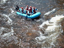
The river is a popular summer destination for fly fishing, whitewater rafting, tubing, and kayaking in the Poudre Canyon, due in large part to the enormous 6,155 feet (1,876 m) elevation variance between its headwaters and its mouth, resulting in a typically very swift current.
[10] From its headwaters downstream, through the city of Fort Collins, the Cache la Poudre River contains abundant populations of self-sustaining wild trout.
As the Cache la Poudre leaves the canyon for the valley to flow through Fort Collins the water quality decreases significantly.
The project has been studied by the United States Army Corps of Engineers since 2005, resulting in a draft Environmental Impact Statement (DEIS) released in September, 2008.
Essentially all the water that is diverted (and pumped) into the off-stream Glade Reservoir would be released back to the river at a later time.
[12] These flow reductions are in addition to existing diversions that have removed approximately 50-60% of the river's water since European settlement began in the valley.
With Save the Poudre stating they will take the Army Corps of Engineers to court if they approve the project, this process could possibly be dragged out to the point that NISP doesn't get any water rights until 2025 instead of the predicted year of 2020.