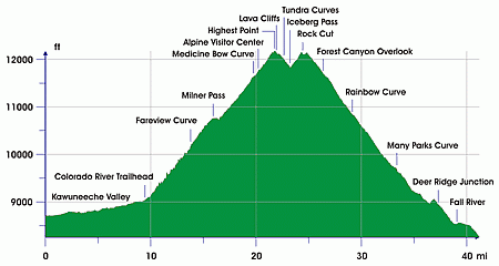
Trail Ridge Road
[5] Trail Ridge had been used by Native Americans to cross the mountains between their home lands in the west and hunting areas on the east side.
The Ute tribe crossing the mountains at Forest Canyon Pass marked their route with stone cairns.
[5] On the west side, about 1880, a wagon road was constructed along the Kawuneeche Valley from the town of Grand Lake to the mining camps of Lulu City and Gaskill.
The camps were abandoned after a few years when short-lived mining boom ended and later the road was used only occasionally by hunters and tourists.
It opened in 1921 and quickly proved inadequate for motor travel as a single-track road with steep grades (up to 16%), tight curves and a short annual season due to snowpack.
[7] Construction began in 1929 and was complete to Fall River Pass by July 1932, with a maximum grade of 7%.


