Lands administrative divisions of Australia
There have been at least 600 counties, 544 hundreds and at least 15,692 parishes in Australia, but there are none of these units for most of the sparsely inhabited central and western parts of the country.
Counties in Australia have little administrative and no political function, unlike those in England or the United States.
Australia instead uses local government areas, including shires, districts, city councils, and municipalities according to the state, as the second-level subdivision.
Within these are individual land parcels such as lots; in total there are estimated to be about 10.2 million of these in Australia.
Detailed maps of these divisions have been required since the introduction of the Torrens title system of a central register of land holdings in South Australia in 1858, which spread to the other colonies.
In 1804 Governor King divided Van Diemen's Land into two counties; Buckingham in the south and Cornwall in the north.
At this time there were five counties already proclaimed in New South Wales: Cumberland, Westmoreland, Camden, Argyle and Northumberland.
Similar award examples exist in the other states and territories that have been subdivided into counties.
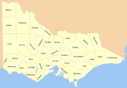
The counties which contain the capital cities have millions of people, while those in remote areas have a very small population.
Wangaratta, for instance, is located at the junction of the Ovens and King rivers, and is thus in three counties; Moira, Delatite and Bogong.
Instead, the Districts Act 1966 divided the ACT into 18 districts:[15] Canberra Central, Woden Valley, Belconnen, Jerrabomberra, Majura, Tuggeranong, Weston Creek, Gungahlin, Stromlo, Kowen, Hall, Coree, Paddys River, Cotter River, Tennent, Rendezvous Creek, Booth and Mount Clear.
The parts of these located in Canberra itself are divided into divisions (i.e. suburbs), sections and blocks.
For example, the National Library of Australia is located in Section 27, Blocks 4, 5 and 8, Division of Parkes, District of Canberra Central.
The original Nineteen Counties were the limits of settlement in the early part of the 19th century.
An example of the way locations are described for Darwin is Darwin International Airport listed as being in "Section 3381, Hundred of Bagot from plan LT089/067A" [21] In Alice Springs, where there are no hundreds or counties, legal documents give the lot number, town and plan number, for example "Lot 8721 Town of Alice Springs, plan(s) LTO96/016"[22] There are currently 322 counties in Queensland, subdivided into 5,319 parishes.
[24] However, since the digitisation and renumbering of the cadastre of Queensland, parishes are no longer used on title documents.
[25] In 2006, the Queensland Department of Natural Resources, Mines and Water was considering abolishing Counties and Parishes and using only Lot and Plan numbers to identify parcels of land.
The County of Adelaide held at least 60% of South Australia's population between 1855 and 1921; the figure rose to 70.6% in 1966.
[30] In many rural areas and historically in residential areas, land is described with the Section number, hundred and county, for example "Section 53, Hundred of Borda, County of Carnarvon",[31] or the allotment number within government towns.
[38] For example: "County of Dalhousie, Parish of Lauriston, being 2 hectares, being Crown Allotment 2, Section 40"[39] or "Parish of Ballarat, County of Grant.. Crown Allotment 29, Section 101, Township of Ballarat East.. as shown on Certified Plan No.
Around the end of the twentieth century, legal documents usually wrote them in the order: land district, location, number.