Caher West Top
Caher West Top (Irish: Cathair na Féinne, meaning 'stone fort of the Fianna')[2] at 973.4 metres (3,193 ft 7 in), is the fifth-highest peak in Ireland on the Irish Vandeleur-Lynam classification, and part of the MacGillycuddy's Reeks range.
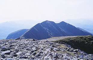
The mountain is located about 500 metres west of Caher East Top and is part of the MacGillycuddy's Reeks of County Kerry.
[3] Caher West Top is often climbed as part of the Coomloughra Horseshoe, which takes 6-8 hours and is described as "one of Ireland’s classic ridge walks".
[6][7] Caher West Top is regarded by the Scottish Mountaineering Club ("SMC") as one of 34 Furths, which is a mountain above 3,000 ft (914.4 m) in elevation, and meets the other SMC criteria for a Munro (e.g. "sufficient separation"), but which is outside of (or furth) Scotland;[8] which is why Caher West Top is sometimes referred to as one of the 13 Irish Munros; it is the only one of the 34 Furths on the official SMC list that has a topographic prominence below 30 metres (98 ft 5 in).
[10] Caher West Top does also not appear in the MountainViews Online Database, 100 Highest Irish Mountains, as the prominence threshold is 100 m (328 ft 1 in).