Cahokia
Cahokia Mounds /kəˈhoʊkiə/ (11 MS 2)[2] is the site of a Native American city (which existed c. 1050–1350 CE)[3] directly across the Mississippi River from present-day St. Louis.
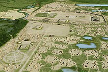
At its apex around 1100 CE, the city covered about 6 square miles (16 km2), included about 120 earthworks in a wide range of sizes, shapes, and functions, and had a population of between 15,000 and 20,000 people.
[5][a] Cahokia was the largest and most influential urban settlement of the Mississippian culture, which developed advanced societies across much of what is now the Central and the Southeastern United States, beginning around 1000 CE.
[7] Today, the Cahokia Mounds are considered to be the largest and most complex archaeological site north of the great pre-Columbian cities in Mexico.
The mounds were later named after the Cahokia tribe, a historic Illiniwek people living in the area when the first French explorers arrived in the 17th century.
The largest pre-Columbian earthen construction in the Americas north of Mexico,[5] the site is open to the public and administered by the Illinois Historic Preservation Division and supported by the Cahokia Mounds Museum Society.
[14] The inhabitants left no written records beyond symbols on pottery, marine shell, copper, wood, and stone, but the evidence of elaborately planned community, woodhenge, mounds, and burials later in time reveal a complex and sophisticated society.
[18] Chronology In the centuries preceding 1000 CE, American Bottom populations were living in small settlements of 50 to 100 people that were used for short durations of 5–10 years.
[19] Later in time, many began to be constructed along cosmologically organizing principles, emphasizing cardinal directions and distinct sectors of society.
Its highly planned large, smoothed-flat, ceremonial plazas, sited around the mounds, with homes for thousands connected by laid out pathways and courtyards, suggest the location served as a central religious pilgrimage city.
[25] At the high point of its development, Cahokia was the largest urban center north of the great Mesoamerican cities in Mexico and Central America.
Intensive farming[33] and textile production[34] occurred in these villages which has been interpreted as supplicant behavior directed towards the central urban core of the city.
Mill Creek chert from southwestern Illinois, most notably, was used in the production of hoes, a high demand tool for farmers around Cahokia and other Mississippian centers.
[37][38] Mississippian culture pottery and stone tools in the Cahokian style were found at the Silvernale site[39] near Red Wing, Minnesota, and materials and trade goods from Pennsylvania, the Gulf Coast, and Lake Superior have been excavated at Cahokia.
Current academic discourse has emphasized religion as a major component in consolidating and maintaining the political power essential to Cahokia's urbanity.
[45] Distinctive rituals have archaeologically documented at these complexes involving tobacco, red cedar, agricultural produce, and female Cahokian flint clay figurines.
[61] Thomas Emerson and Kristin Hedman argue that Cahokia's large immigrant population was a factor in the city's ultimate fragmentation, as differing languages, customs, and religions obstructed the creation of a cohesive Cahokian cultural identity.
[63] Finely crafted artifacts from Cahokia, such as copper repoussé plates and engraved shell, appear at powerful centers such as Moundville and Etowah only after 1250 CE.
Ponca oral tradition specifies their ancestor's time in Cahokia, calling the city or its location "P'ahe zide" [red hill].
Many Indigenous people groups and nations including the Cherokee, Choctaw, Chickasaw, and Muscogee-Creek, carry on their moundbuilding traditions similar to those of Cahokia.
[23] Thomas Emerson and Kristin Hedman attribute the discovery of Cahokian individuals with low-maize diets to the existence of hunter-gatherer immigrant communities who had not yet adopted maize as a staple food source.
Pleasant, however, argues that these models of Cahokia's soil longevity are flawed, because it is based on modern understandings of crop yields that assume the use of plows.
To achieve that, thousands of workers over decades moved more than an estimated 55 million cubic feet (1,600,000 m3) of earth in woven baskets to create this network of mounds and community plazas.
It was built with a symbolic quadripartite worldview and oriented toward the four cardinal directions with the main east–west and north–south axes defined with Monks Mound near its center point.
[107] Alleen Betzenhauser and Timothy Pauketat argue that upwards of 20 percent of Cahokia's neighborhood structures did not serve domestic functions, but were rather intended to facilitate engagement with non-human spiritual beings as part of an animistic religion.
In addition, a cache of sophisticated, finely worked arrowheads in a variety of different styles and materials was found near the grave of this important man.
Analysis of copper found during excavations showed that it had been annealed, a technique involving repeatedly heating and cooling the metal as it is worked, as blacksmiths do with iron.
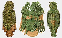
[117] Artisans produced religious items, such as long-nosed god maskettes, ceremonial earrings with a symbolic shape, thought to have been used in fictive kinship rituals.
[120][121][122][123][better source needed] The Cahokia Woodhenge was a series of large timber circles located roughly 850 m (2,790 ft) to the west of Monks Mound.
[130][better source needed] The Illinois Historic Preservation Division that oversees the Cahokia site hosts public sunrise observations at the vernal and autumnal equinoxes and the winter and summer solstices.