California's 7th congressional district
Containing most of the state capital of Sacramento, the 7th is currently a solidly Democratic district with a D+17 rating from the Cook Partisan Voting Index.
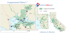
Registered voter statistics comes from the California Secretary of State: As of 2023, California's 7th congressional district is located in the Sacramento Valley, and encompasses most of Sacramento County and parts of Yolo.
The 7th and 6th districts are partitioned by the Sacramento River, American River, Fair Oaks Blvd, Watt Ave, Kiefer Blvd, Highway 16, Bradshaw Rd, Highway E2, and Stonehouse Dr.
The 7th district takes in the south side of the city of Sacramento, the cities of Galt and Elk Grove, and the census-designated places Florin, Parkway, Arden-Arcade, Vineyard, Lemon Hill, Wilton, Rancho Murieta, Fruitridge Pocket, Freeport, Franklin, Clay, Herald, Hood, Courtland, Walnut Grove, and Isleton.
They are partitioned by Highway 84 and Elkhorn Slough on the southern border, and by County Rd 126, Tule Canal, Toe Drain Canal, Highway 84, Babel Slough Rd, and Pumphouse Rd.