California State Route 75
Since then, various proposals have taken place to relieve commuter traffic between San Diego and Naval Air Station North Island that traverses the city of Coronado.
SR 75 begins as Palm Avenue at I-5 in the Nestor neighborhood of San Diego, heading westbound from the Southland Plaza shopping center.
[5] After this, SR 75 passes through the United States Naval Amphibious Base for a few miles before entering downtown Coronado.
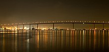
[6] It is officially designated as a scenic route for nearly its entire length, from the Imperial Beach city limit to Avenida del Sol in Coronado, and the portion across the Coronado Bridge[7] meaning that it is a substantial section of highway passing through a "memorable landscape" with no "visual intrusions", where the potential designation has gained popular favor with the community.
[12] The process of paving portions of Orange Avenue began in 1893, with an estimated cost of $50,000 (about $2 million in 2023 dollars);[13] three miles (4.8 km) of sidewalks were also included.
"[22] The State Highway Commission allocated $25,000 (about $235,000 in 2023 dollars)[13] to install traffic signals at the intersection of SR 75 and US 101 in March 1951.
[24] By July 1952, it had been disclosed that some local businesses near Palm City had lodged opposition to the widening of the highway after $500,000 (about $4.61 million in 2023 dollars)[13] had been allocated to the project.
[32] In 1955, the California Senate approved $200,000 (about $1.78 million in 2023 dollars)[13] to conduct a study regarding a possible vehicular tunnel from San Diego to Coronado.
[42] By 1969, Palm Avenue was the primary commercial street in Imperial Beach, and was described by the San Diego Union as "a strip of large signs and businesses.
[44] In September, the City of Coronado added Orange Avenue south of Third Street as a truck route leading to the base.
The plan was to build another highway along the northern and eastern shore of Coronado Island, to bypass the busy residential and commercial districts and provide easy access to the Silver Strand from the western end of the bridge.
Critics contended that the highway would block the view of San Diego Bay, and that the city would be unable to alter traffic patterns in the meantime.
The renumbering was to reduce confusion with the Coronado portion, according to Caltrans regional director Jacob Dekema; new signs were to be put into place shortly thereafter.
[58] A major renovation of the bridge was scheduled for late 1992, which would include a movable barrier to prevent head-on collisions and necessary resurfacing of the roadway.
[61] The speed limit was decreased to 25 miles per hour (40 km/h) in October 2005 along Third and Fourth streets, after traffic increased by 20 percent following the removal of the toll.
[64] The city endorsed a proposed study in 2004 to determine possible alternatives to resolve the traffic issues, which included keeping the status quo.
[66] This concluded ten years of studies and proposals by the city of Coronado to find a way to reduce traffic to the naval station during rush hour.
[68] Efforts were underway by Imperial Beach city officials to improve the reputation and economic standing of the Palm Avenue area in the first decade of the 21st century.
The area was described by the San Diego Union-Tribune as a "hodgepodge of vacant land and aging apartment buildings and businesses, many in need of a coat of paint" in 2003.
[72] In September 2012, the Imperial Beach city council raised objections over the Caltrans decision to increase the speed limit on SR 75 to 45 miles per hour (72 km/h) from 40 miles per hour (64 km/h) on the portion of the highway from Delaware Street to the western Imperial Beach city limit due to concerns about safety.
[73] Except where prefixed with a letter, postmiles were measured on the road as it was in 1964, based on the alignment that existed at the time, and do not necessarily reflect current mileage.