Calmont (hill)
323051; established in 1979; 1187.48 km2), in the Special Area of Conservation of Hillsides and Side Valleys of the Lower Moselle (Moselhänge und Nebentäler der unteren Mosel, FFH No.
In connexion with the excavations this Gallo-Roman ambulatory temple was reconstructed[4] and opened on 16 May 2009[5] In the late 20th century only part of the original vineyards were still being cultivated.
Next to the hut there, which is opened from Easter to October as a Straußwirtschaft, is an "observation plateau" from where there are good views, especially of the great loop in the Moselle, 285 m below, along with the nearby ruins of Stuben Abbey with, downstream, the villages of Neef, Bremm and Ediger-Eller.
Along the southern foot of the Calmont, running from west to east between the Moselle villages of Bremm and Ediger-Eller is the B 49 federal highway.
[8] Near the Monument to the Wartime Generation is a launch area for paragliders who can fly over the Moselle valley in suitable wind conditions.
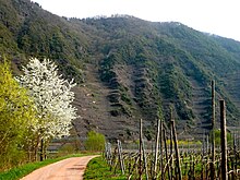
The Calmont massif is like a huge concave mirror in the Moselle valley and, with its southerly orientation and slate bedrock, offers ideal conditions for the creation of thermal upcurrents.