Eifel
The Eifel (German: [ˈaɪfl̩] ⓘ; Luxembourgish: Äifel, pronounced [ˈæːɪfəl]) is a low mountain range in western Germany, eastern Belgium and northern Luxembourg.
The Eifelian stage in geological history is named after the region because rocks of that period reach the surface in the Eifel at the Wetteldorf Richtschnitt outcrop.
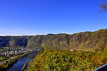
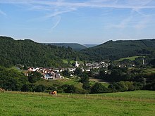
The rivers draining into the Moselle, Rhine and Meuse, such as the Our, Kyll, Ahr, Brohlbach and Rur, have cut deep into the edge of the Eifel and formed larger valleys.
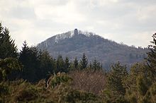
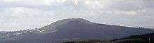
From north to south they are: the Michelsberg, Häuschen and Teufelsley in the north; the Adert, Hohe Acht and Raßberg in the northeast; the Hochkel, Nerotherkopf, Dietzenley and ruins of the Kasselburg in the central area; the Prümer Kalvarienberg, Hartkopf and Prümer Kopf in the east, the Steineberg and Mäuseberg near Daun, the Hochsimmer and Scheidkopf near Mayen; the Eickelslay and Absberg in the southeast; and the Krautscheid and Hohe Kuppe in the southwest.
Impoundment of these streams, especially in the North Eifel has led to the creation of very large reservoir, such as the Rursee, which is the second largest in Germany by volume, and the Urftsee.
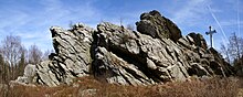
[34][37] The Eifel and its western continuation into Belgium, the Ardennes, are the remains of a Variscan truncated upland, much of it 400 million years old, that is part of the Rhenish Massif (Rheinisches Schiefergebirge).
The basement in the Eifel, as in the other regions of the Rhenish Massif, consists mainly of Devonian slates, sandstones and limestones, laid down in an ocean south of the Old Red Continent[38] and folded and overthrust in the Variscan orogeny.
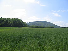
This led to the streams and rivers cutting into the gently rolling landscape resulting in the present appearance of the low mountain range with its flat plateaus and deeply incised valleys.
Due to numerous recent research projects, climate changes since the last ice age can be traced in detail in the Eifel region.
In the eastern Eifel, volcanism began about 500,000 years ago in the area of today's Laacher See; it extended to the Neuwied Basin to the south, and crossed the Rhine to the east.
East Eifel volcanism came to an end with a huge eruption, as a result of which the magma chamber emptied and collapsed, creating a caldera.
[42] Research has shown that the volcanism is still active; the Eifel region is rising by 1–2 mm per year and there are escaping gases, for example, carbon dioxide (CO2) in the Laacher See.
The Eifel is in the Atlantic climate zone with its relatively high precipitation; winters that are moderately cold and long with periods of snow; and summers that are often humid and cool.
At the time of the Roman Empire the whole mountain range between the rivers Rhine, Meuse and Moselle was called Arduenna silva ("high forest").
One of them, the Eifelgau, covered the source regions of the rivers Erft, Urft, Kyll and Ahr, i.e. predominantly the northern and northwestern foothills of the present Eifel in the eastern half of the Arduenna silva of the Romans.
Dittmaier gives three possible explanations: "marshy region", "plain, heath" and "heathland", which would all bring geology and vegetation into harmony.
The construction of the Siegfried Line was followed, from September 1944 to January 1945, by violent battles and the Ardennes Offensive, especially in the northern Eifel, which still bears witness to the legacy of the war: ruins of old bunkers and parts of tank barriers.
The abundance of timber, which was needed for smelting, and of watercourses, which were indispensable for the preparation and operation of hammer mills and bellows, made it possible for the Eifel to be an important supra-regional economic area even in the late Middle Ages.
[54][55] As a traditionally isolated land, in which the population kept a quiet and simple way of life, the Eifel offered fertile soil for lively folk poetry.
In addition, there are countless horror stories of witches, undead, headless riders, revenants and werewolves, which - like those in the neighbouring Ardennes region - survived into the 20th century.
Inspired by Romanticism, in which folklore was seen as a rich source of unadulterated motifs and forms, collections of stories and adaptations of Eifel folk tales emerged.
The most prominent collector was Bonn professor of folklore, Matthias Zender, who was born in Zendscheid and who, as a student between 1929 and 1936, collected about 10,000 stories, folk tales and jokes from the Eifel/Ardennes region, of which 2,000 were published.
In 2010, Ute Bales wrote a novel about his life, which was awarded the special prize by the jury in the Rhineland-Palatinate Book of the Year competition (Buch des Jahres Rheinland-Pfalz).
These include Jochen Arlt (who has also contributed to regional literature as the editor of several Eifel anthologies), Theo Breuer, Ursula Krechel and Norbert Scheuer.
Jochen Arlt's poem Einkaufn gehen in Münstereifel may be read in the most important German poetry collection, The Great Conrady.
The best-selling author of the subsequent naturalism movement, wrote two great literary monuments about the Eifel with her novels, Kreuz im Venn and Weiberdorf.
This literature challenges us to confront the region and its people, especially where there is no attempt to romanticize the Eifel, but where hopelessness and despair in the face of poverty and misery, intellectual narrowness or rigid systems of values become apparent.
The characteristic of the Eifel landscape and its inhabitants is the starting point of a narrative style that shows people as "lonely, lost, in a misunderstood place" in and with their suffering, as in the novel Kamillenblumen (2010) about the peddler, Traud, from Kolverath.
Harald Schneider (born 1962) is the author of the children's detective series Die Meisterschnüffler, an interactive read that leads readers from 8 years old to different locations in the Eifel.
Carola Clasen, Carsten Sebastian Henn, Andreas Izquierdo, Rudolf Jagusch, Martina Kempff, Elke Pistor, Edgar Noske and Hans Jürgen Sittig are other authors who contribute to the genre of Eifel crime novels.