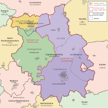
Cambridgeshire
It is bordered by Lincolnshire to the north, Norfolk to the north-east, Suffolk to the east, Essex and Hertfordshire to the south, Northamptonshire to the west, and Bedfordshire to the south-west.
The remainder of the county is rural, and contains the city of Ely in the east, Wisbech in the north-east, and St Neots and Huntingdon in the west.
[4] Cambridgeshire is noted as the site of Flag Fen in Fengate, one of the earliest-known Neolithic permanent settlements in the United Kingdom, compared in importance to Balbridie in Aberdeen, Scotland.
Must Farm quarry, at Whittlesey, has been described as "Britain's Pompeii due to its relatively good condition, including the 'best-preserved Bronze Age dwellings ever found in the UK'".
Covering a large part of East Anglia, Cambridgeshire today is the result of several local government unifications.
It is associated with Cambridgeshire for ceremonial purposes such as Lieutenancy and joint functions such as policing and the fire service.
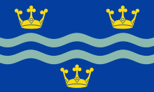
The design features three golden crowns, two on the top, one on the bottom that are separated by two wavy lines in the middle.
[15] Large areas of the county are extremely low-lying and Holme Fen is notable for being the UK's lowest physical point at 2.75 m (9 ft) below sea level.
The highest point of the modern administrative county is in the village of Great Chishill at 146 m (480 ft) above sea level.
The historic county top is close to the village of Castle Camps where a point on the disused RAF airfield reaches a height of 128 metres (420 ft) above sea level (grid reference TL 63282 41881).
The county contains eight Parliamentary constituencies: This is a chart of trend of regional gross value added of Cambridgeshire at current basic prices published (pp.
RAF Alconbury, three miles north of Huntingdon, is being reorganised after a period of obsolescence following the departure of the USAF, to be the focus of RAF/USAFE intelligence operations, with activities at Upwood and Molesworth being transferred there.
Close to Cambridge is the so-called Silicon Fen area of high-technology (electronics, computing and biotechnology) companies.
Cambridgeshire has a comprehensive education system with over 240 state schools, not including sixth form colleges.
The town of Newmarket is surrounded on three sides by Cambridgeshire, being connected by a narrow strip of land to the rest of Suffolk.
[19] Cambridgeshire has a maritime temperate climate which is broadly similar to the rest of the United Kingdom, though it is drier than the UK average due to its low altitude and easterly location, the prevailing southwesterly winds having already deposited moisture on higher ground further west.
Snowfall is slightly more common than in western areas, due to the relative winter coolness and easterly winds bringing occasional snow from the North Sea.
[30] On 6–7 June 2015, the inaugural Tour of Cambridgeshire cycle race took place on closed roads across the county.
The Gran Fondo event was open to the public, and over 6000 riders took part in the 128 km (80 mi) race.
Cambridge is home to the Kettle's Yard gallery and the artist-run Aid and Abet project space.