Canajoharie Creek
[5] Canajoharie Creek begins in a forested area north of the village of Cherry Valley along St. Butler Road.
Shortly after crossing under Vandeusenville Road it meets the confluence of Bowmans Creek, just east of the hamlet of Sprout Brook.
[9] Shortly after crossing under Mc Ewan Road, it curves to the east and begins to parallel Maple Hill.
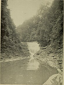
[10][4] Roughly halfway along Maple Hill, the creek enters into the Canajoharie Gorge, as it passes Wintergreen Flats.
[10][4] The first Europeans to settle along the creek were Hendrick Schrembling and Marte Janse Van Alstyne around 1730 in the present village of Canajoharie.
Schrembling remained in the area and ran a tavern, store and grist mill, but moved away by the end of the American Revolution.
[17] In April 2019, high water from storms caused a retaining wall to collapse in the village of Canajoharie.
Their territory ranged north to the St. Lawrence River, southern Quebec and eastern Ontario; south to greater New Jersey and into Pennsylvania; eastward to the Green Mountains of Vermont; and westward to the border with the Iroquoian Oneida Nation's traditional homeland territory.
The giant pothole located in the gorge, known as "the boiling pot", was formed by rocks eroding the surface of the limestone bed.
Some parts are limestone mixed with shale of the Trenton Group, which was deposited during the Trentonian stage of the middle to late Ordovician (circa 448-458 Ma).
[24] The United States Geological Survey (USGS) maintains two stream gauges along Canajoharie Creek.
The upper one, in operation since 1993, is located 10 feet (3.0 m) upstream from the bridge on Mc Ewan Road, and 2.3 miles (3.7 km) southwest of the village of Canajoharie.
[28] Another former stream gauge was located southwest of the hamlet of Sprout Brook where Mill Road crosses the creek.
[30] The DEC rates the Canajoharie Creek's water quality at Class C, suitable for fishing and non-contact human recreation.