Canton 10
Their use as the official symbols of the canton was deemed unconstitutional by the Constitutional Court of the Federation, because "they only represented one constituent nation".
Under the Ottoman Empire, peasants who remained Catholic or Orthodox were hostile to Turkish officials and Islamised landowners.
After the creation of the NDH and its administrative division, most of the area of today's Herzeg-Bosnia County was part of the Great Parish of Pliva and Rama with its seat in Jajce, while the smaller northern part belonged to the Great Parish of Krbava and Psata with its seat in Bihać.
After the defeat of the Axis powers in 1945, the area of Herzeg-Bosnia County became part of the then-federal unit of SFR Yugoslavia, Bosnia and Herzegovina.
With the independence of Bosnia and Herzegovina in the northern and western part of Herzeg-Bosnia County under the leadership of the SDS, the Serb majority areas sided with the Army of Republika Srpska killing Croats and Bosniaks in Drvar, Grahovo, Glamoč, attacking Kupres and shelling Livno and surrounding settlements.
They attacked and captured Grahovo, Glamoč[13] and Drvar, which, together with other victories of the HVO, HV and the RBiH Army, created the conditions for the signing of the Dayton Peace Agreement.
The total area of the canton is approximately 4,934 square kilometres (1,910 sq mi), a tenth of the surface of Bosnia-Herzegovina and c. 19% of the Federation.
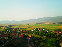
The natural and geographical features of this area are diverse, ranging from fertile and vast fields and vast pastures, rivers and lakes to centuries-old deciduous and evergreen forests, and provide abundant opportunities for life and economic development based on agricultural production, livestock and the timber industry.
The Dinarides form part of a chain of mountains that stretch across southern Europe and isolate Pannonian Basin from the Mediterranean Sea.
Canton 10 includes five municipalities: Drvar, Bosansko Grahovo, Glamoč, Kupres, and Tomislavgrad and one township: Livno.
After Croat forces captured Grahovo, Glamoč[13] and Drvar in the summer and fall of 1995, 12,000 to 14,000 Serbs fled to Banja Luka.
In 2013, Canton's population included approximately 77% Croats, 13% Serbs and 9.6% Bosniaks; all other ethnicities combined made up the remaining <0.4%.
The canton has significant natural resources, with large reserves of coal and timber, as well as hydro & wind power.
The natural and geographical features of this area are diverse, from fertile and vast fields and vast pastures, rivers and lakes to centuries-old deciduous and evergreen forests, and provide abundant opportunities for life and economic development based on agricultural production, livestock and the timber industry.
The ecologically clean and intact nature, the temperate continental climate, the geographical position and the proximity and good transport connections with other parts of Bosnia and Herzegovina and neighboring Croatia, especially Dalmatia, which traditionally and economically gravitate, are important factors for the economic development of this area.
The canton suffered severe damage during the last war and is one of the worst affected areas in the Federation of Bosnia and Herzegovina.
Viewed from the revenue aspect of 1998 and 1999, there was a significant increase in construction, agriculture and forestry, as well as transportation, industry and mining.
The main economic branches of Canton 10 according to the number of employees are the wholesale and retail trade, the processing industry and agriculture, forestry and fishing.
Una-Sana Central Bosnia Posavina Herzegovina-Neretva Tuzla West Herzegovina Zenica-Doboj Sarajevo Bosnian Podrinje Canton 10 Una-Sana Central Bosnia Posavina Herzegovina-Neretva Tuzla West Herzegovina Zenica-Doboj Sarajevo Bosnian Podrinje Canton 10