Canton of St. Gallen
The canton of St. Gallen is an artificial construct of various historical territories, defined by Napoleon Bonaparte in the Act of Mediation in 1803.
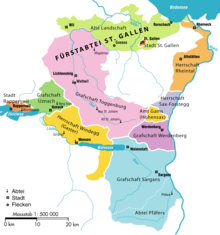
Both the city and the abbey were associates (Zugewandte Orte) of the Old Swiss Confederacy, but unlike Appenzell never joined as full members.
Before the 1798 French invasion, the territory of the modern canton consisted of the free city of St. Gallen, the territories of the Abbey of St. Gallen (including Fürstenland and Toggenburg), the free city of Rapperswil, Pfäfers Abbey, Sargans and the independent lordships (bailiwicks) of Rheintal, Sax-Forstegg, Hohensax, Werdenberg, Windegg and Uznach.
However, the two new Cantons had immediate financial problems and were forced to institute a number of unpopular taxes and laws.
When the War of the Second Coalition broke out in 1799, an Austrian army marched into eastern Switzerland and returned the Prince-Abbot to his throne at the Abbey.
In 1803, as part of the Act of Mediation, the area joined the Swiss Confederation as the Canton of St.
[citation needed] Due to continuing confessional squabbles over the organisation of schools, the canton eventually placed education under its authority in 1861.
[6] The mountains of the canton include part of a thrust fault that was declared a geologic UNESCO World Heritage Site, under the name Swiss Tectonic Arena Sardona, in 2008.
[11] The historical population is given in the following table: Agricultural activity consists predominantly of dairy farming and cattle breeding in the mountainous areas.
There is a thermal spa in Bad Ragaz and another in St. Margrethen and a great number of winter sports facilities.
Higher educational institutions include the Hochschule für Technik Rapperswil and the University of St. Gallen.