Canton of Zurich
[c] It is also a global financial center and has the fourth-highest GRP in Switzerland behind Basel-Stadt, Zug and Geneva by GDP per capita.
[6][7] Nine of these UNESCO World Heritage sites are located on the shore of Lake Zurich: Freienbach–Hurden Rosshorn, Freienbach–Hurden Seefeld, Rapperswil-Jona/Hombrechtikon–Feldbach, Rapperswil-Jona–Technikum, Erlenbach–Winkel, Meilen–Rorenhaab, Wädenswil–Vorder Au, Zürich–Enge Alpenquai and Kleiner Hafner.
Within an area of about 40 square kilometres (15 sq mi) around Lake Zurich, there also the settlements Greifensee–Storen/Wildsberg at the Greifensee and Wetzikon–Robenhausen at the Pfäffikersee.
[8] Zurihgauuia (Zürichgau) was a subdivision of Turgowe (Thurgau) in the Duchy of Alamannia, consisting roughly of the territory between Reuss and Töss.
In c. 760, an administrative re-organisation under counts Ruthard and Warin exempted the castle town of Zurich from comital rule.
Zürichgau (Zurichgeuue) remained a nominally separate territory in the later 9th century but was often ruled by the same count as Thurgau.
By the 13th century, Zürichgau was divided between the Habsburgs and the Kyburger, who held the territory west and east of Lake Zurich, respectively.
The northern parts up to the river Rhine came to the canton after the city of Zurich purchased Winterthur from the Habsburgs in 1468.
At this point, almost all of the territory of the modern canton (as well as some territories beyond its modern borders) was owned by Zurich; exceptions include Wülflingen (acquired 1760), Buch (acquired 1761), Dietikon, which was a condominium, and Rheinau (owned by Rheinau Abbey).
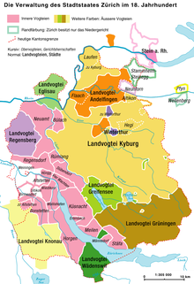
In the 18th century, the "inner bailiwicks" (Innere Vogteien) were under direct administration of city officials, while the "outer bailiwicks" (Äussere Vogteien) were ruled by the reeves of Kyburg, Grüningen, Greifensee, Eglisau, Regensberg, Andelfingen, Wädenswil, and Knonau.
Under the threat of intervention of the other radical-liberal cantons of the Confederacy, the provisional government declared that the 1831 constitution would remain in effect.
Escher governed the canton almost in monarchical fashion, and was popularly dubbed Alfred I. or Tsar of All Zurich.
Escher controlled all cantonal institutions, at first with very little political opposition, expunging all trace of the conservative takeover of 1839.
The cantonal government was accused to continue the system of aristocratic rule liberalism had claimed to abolish.
The oppositional Democratic Movement was centered in Winterthur, led by mayor Johann Jakob Sulzer and publicist Salomon Bleuler.
They succeeded in imposing the introduction of the direct democratic instrument of the popular initiative in 1865, which precipitated a revision of the cantonal constitution.
In 1877, the Cantonal Laboratory Zurich was founded in order to regulate the quality of food and drinking water.
The first cantonal chemist was Haruthiun Abeljanz, who was instrumental in setting up the new laboratory, moving it from an unpromising start in converted storage rooms to Lintheschergasse 10, which was located just behind the Pestalozziwiese, a memorial to Johann Heinrich Pestalozzi.
Rapid urbanisation expanded throughout the canton and beyond in the final decades of the 20th century, further accelerated by the S-Bahn from 1990, with only a few municipalities in Weinland, Knonaueramt and Oberland remaining out of easy commuting distance to the city.
It is characterized by Glacial landform and traversed by a series of rivers generally flowing south-east to north-west, listed west to east: Reuss, Reppisch, Sihl, Linth-Limmat (forming Lake Zurich), Glatt, Töss and Thur.
It also has an international border with the German district of Waldshut and though only for 460 m (1,510 ft)) the district of Konstanz in Baden-Württemberg owing to its short border with Stemmer, an outlying hamlet belonging to the municipality which forms the small German enclave of Büsingen am Hochrhein.
The canton can be roughly divided into the city and lake, the Unterland in the northwest, the Oberland in the southeast, the Weinland and Winterthur in the northeast, and the Knonaueramt southwest of the Albis.
[12] Most of the canton consists of shallow river valleys which drain towards the High Rhine to the north.
The Schnebelhorn is a mountain located near Fischenthal in the Töss Valley, between the cantons of Zurich (west) and St. Gallen (east).
The vast majority of the canton lies to the south of the Rhine, the exceptions being Rafzerfeld as mentioned and a tiny portion of the village of Laufen-Uhwiesen called Nohl.
Even though Zwingli died in battle in 1531, the canton remained a stronghold of the Swiss Reformed Church over the following centuries.
Small and middle sized companies are important contributors to the economy of the canton of Zurich.
The number of jobs in the primary sector was 8,120, of which 7,771 were in agriculture, 320 were in forestry or lumber production and 29 were in fishing or fisheries.
The centre for transport is Zurich, where a great number of local railways connect to national and international rail links.
The railway station of the city of Zurich, Zürich Hauptbahnhof, is one of the busiest in Europe, counting the number of arriving and departing trains.