Capitol Reef National Park
The park was established in 1971[5] to preserve 241,904 acres (377.98 sq mi; 97,895.08 ha; 978.95 km2) of desert landscape and is open all year, with May through September being the highest visitation months.
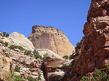
This warp, probably caused by the same colliding continental plates that created the Rocky Mountains, has weathered and eroded over millennia to expose layers of rock and fossils.
The park is filled with brilliantly colored sandstone cliffs, gleaming white domes, and contrasting layers of stone and earth.
The area was named for a line of white domes and cliffs of Navajo Sandstone, each of which looks somewhat like the United States Capitol building,[9] that run from the Fremont River to Pleasant Creek on the Waterpocket Fold.
Fremont-culture Native Americans lived near the perennial Fremont River in the northern part of the Capitol Reef Waterpocket Fold around the year 1000.
They irrigated crops of maize and squash and stored their grain in stone granaries (in part made from the numerous black basalt boulders that litter the area).
In 1872 Almon H. Thompson, a geographer attached to United States Army Major John Wesley Powell's expedition, crossed the Waterpocket Fold while exploring the area.
Following the American Civil War, officials of the Church of Jesus Christ of Latter-day Saints in Salt Lake City sought to establish missions in the remotest niches of the Intermountain West.
[7] Mormons settled the Fremont River valley in the 1880s and established Junction (later renamed Fruita), Caineville, and Aldridge.
The resulting Oyler Mine in Grand Wash produced uranium ore. By 1920 no more than ten families at one time were sustained by the fertile flood plain of the Fremont River and the land changed ownership over the years.
[11] In 1933, Pectol was elected to the legislature and almost immediately contacted President Franklin D. Roosevelt and asked for the creation of "Wayne Wonderland National Monument" out of the federal lands comprising the bulk of the Capitol Reef area.
[11] During the 1950s Kelly was deeply troubled by NPS management acceding to demands of the U.S. Atomic Energy Commission that Capitol Reef National Monument be opened to uranium prospecting.
[11] In 1958 Kelly got additional permanent help in protecting the monument and enforcing regulations; Park Ranger Grant Clark transferred from Zion.
The year Clark arrived, fifty-six thousand visitors came to the park, and Charlie Kelly retired for the last time.
[11] During the 1960s (under the program name Mission 66), NPS areas nationwide received new facilities to meet the demand of mushrooming park visitation.
At Capitol Reef, a 53-site campground at Fruita, staff rental housing, and a new visitor center were built, the latter opening in 1966.
[7] Visitation climbed dramatically after the paved, all-weather State Route 24 was built in 1962 through the Fremont River canyon near Fruita.
State Route 24 replaced the narrow Capitol Gorge wagon road about 10 mi (16 km) to the south that frequently washed out.
[7] Preservationists convinced President Lyndon B. Johnson to set aside an enormous area of public lands in 1968, just before he left office.
By 1970, Capitol Reef National Monument comprised 254,251 acres (102,892 ha) and sprawled southeast from Thousand Lake Mountain almost to the Colorado River.
The action was controversial locally, and NPS staffing at the monument was inadequate to properly manage the additional land.
[7] In September 1970, United States Department of Interior officials told a house subcommittee session that they preferred about 254,000 acres (103,000 ha) be set aside as a national park.
The legislation—'An Act to Establish The Capitol Reef National Park in the State of Utah'—became Public Law 92-207 when it was signed by President Richard Nixon on December 18, 1971.
The area including the park was once the edge of a shallow sea that invaded the land in the Permian, creating the Cutler Formation.
Conglomerate, followed by logs, sand, mud, and wind-transported volcanic ash, then formed the uranium-containing Chinle Formation.
Near the end of the Cretaceous period, a mountain-building event called the Laramide orogeny started to compact and uplift the region, forming the Rocky Mountains and creating monoclines such as the Waterpocket Fold in the park.
[20] Highway 12 and a partially unpaved scenic backway named the Burr Trail provide access from the west through the Grand Staircase–Escalante National Monument and the town of Boulder.
[18] A variety of activities are available to tourists, both ranger-led and self-guided, including auto touring, hiking, backpacking, camping,[21] bicycling (on paved and unpaved roads only; no trails), horseback riding, canyoneering, and rock climbing.
Overnight camping as part of the canyoneering trip is permitted, but a free backcountry pass must be requested from the visitor center.
A paper by George Huddart, details the park's commitment to working with citizens to maintain the route as well as the vegetation and rocks.