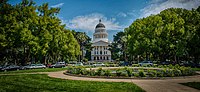
Capitol Mall
Their initial allocation for the construction of the dedicated Capitol building in 1860 only provided for a 4 block parcel of land bordered by L, N, 10th, and 12th streets.
The advent of the automobile and the new Legislative Route 6 leading to the Capitol further emphasized how the appearance of the Capitol from the riverfront reflected California's fortunes, as urban planning advocate Charles Mulford Robinson petitioned the city and the state to emulate Pierre L’Enfant's ideals for the National Mall in Washington, D.C. in 1907.
"[3][5][6] Governor C. C. Young renewed efforts for the widening of M Street into a grand mall to create “the Pennsylvania Avenue of California” in 1929.
[3] Mall proposals were placed on the backburner during the wars, and despite the fact much of Sacramento's Japantown was decimated by the evacuation and incarceration of Japanese Americans during the war, California's population doubled due to its strong wartime defense industry production, many who moved into the vacated Japanese areas, especially those who were prohibited from finding housing elsewhere else due to racial housing covenants, often far exceeding the capacity for those properties as affluent residents moved out to the growing suburburan migration of the 1950s.
[5][6] That migration and federal investment in urban renewal during the post war era jumpstarted the city's attention towards finally creating the Mall, if only to give government the excuse to seize the overcrowed ethnic ghettos through eminent domain, such as what was then called Sacramento's "West End" filled with minorities with no place else to go.
The Sacramento Redevelopment Agency (SRA) was created in 1950 to deal with the challenge of enforcing the State's wishes, acquiring approximately 15 square blocks for the Capitol Mall Project, and publicly demolishing an 1870's private home acquired through eminent domain by the agency in a special ceremony in what was publicized as a “slum clearance project,” and opening those parcels up to private investment compatible with the State's mall concept.
[5][8] By 1961, the initial plan to create a 52 foot grassy median separating 2 wide streets with an 8 footwide landscape setback planted with Linden trees for a total of 180 feet between the buildings north and south of the Mall was underway.
J. W. Wilson from the State Division of Highways was assigned as the design engineer for the project with Donald Van Riper as the landscape architect.
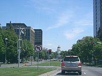
Unfortunately, an earlier plan to include a round-about encircling a monument or obelisk on the western end of The Mall was abandoned due to the unanticipated construction of Interstate 5 to run along the river through the city, and deliberately built below grade so not to interrupt the clear line of sight between the Capitol and the Tower Bridge.
Located within the Wells Fargo Center: Il Fornaio, a popular restaurant; and Price Waterhouse Coopers, a major tenant.