California State Route 99
The entire segment from Wheeler Ridge to Sacramento has been upgraded as of January 2016 to a freeway at least four lanes wide, and the California Department of Transportation (Caltrans) plans to further upgrade the segment to a minimum width of six lanes and also bring it into compliance with Interstate Highway standards as a parallel route to I-5 for Los Angeles–Sacramento traffic.
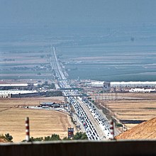
[6] It passes through the major cities of the San Joaquin Valley, including Bakersfield, Delano, Tulare, Visalia, Fresno, Madera, Merced, Modesto, and Stockton.
[7] The trees are to be removed in 2025 as part of widening the segment to six lanes, to be replaced by 15 pines and 15 palms to the west of the highway.
As SR 99 leaves Chico, the highway reverts to a 2-lane road before crossing into Tehama County and passing through rural areas and the town of Los Molinos.
The route then curves to the west and terminates at the junction with SR 36, approximately 1.5 miles (2.4 km) from I-5 in Red Bluff.
[22] The paved county road south from El Centro to the Mexican border became a state highway in mid-1931,[23] and part of US 99 in mid-1932.
[25] A short-lived split also existed between Manteca and Stockton in the early 1930s, with US 99E becoming the main route and US 99W becoming an extended SR 120 where not concurrent with US 50.
The other proposed alternative was the West Side Freeway, which would bypass all the Central Valley communities and thus provide a faster and more direct north–south route through the state.
At the same time Route 99 was defined legislatively to run from I-5 near Wheeler Ridge to Red Bluff, but it was only marked as SR 99 between Sacramento and Yuba City, since the remainder was still US 99 or US 99E.
[20] The southern end of US 99 was moved further north to Sacramento in late 1966 and SR 99 was extended to Wheeler Ridge; the rest of former US 99 to Los Angeles was either I-5 or the locally maintained San Fernando Road.
During the 20th century, Caltrans gradually widened Route 99 into a four-lane expressway for the length of the entire segment from Wheeler Ridge to Sacramento.
As traffic levels along the Route 99 corridor continued to increase, the at-grade intersections on the expressway became extremely dangerous.
Drivers on cross-streets who needed to cross the expressway often had to wait for many minutes at those intersections to find suitable gaps in which to dart across heavy through traffic on Route 99 moving at near-freeway speeds.
Therefore, Caltrans upgraded or replaced those intersections one-by-one with freeway interchanges, and often added frontage roads for access to adjacent parcels.
This work proceeded very slowly over several decades, as Caltrans needed to balance the rising level of danger at the rural intersections on Route 99 with other urgent construction priorities in California's rapidly growing metropolitan areas.
By 2012, there was only one remaining expressway segment with at-grade intersections on Route 99 between Sacramento and Wheeler Ridge, in Merced County between the cities of Chowchilla and Atwater.
On December 11, 2012, Caltrans commenced construction on a project to upgrade that segment to a six-lane freeway with full access control.
[35] On January 15, 2016, Caltrans officially opened the Plainsburg Road interchange, which completed the conversion of Route 99 south of Sacramento to a freeway built to near-interstate standards.
Caltrans once suggested the route could be designated as either I-7 or I-9, in accordance with the Interstate Highway System's numbering standards (being just east of and parallel to I-5).
[37] Except where prefixed with a letter, postmiles were measured on the road as it was in 1964, based on the alignment that existed at the time, and do not necessarily reflect current mileage.