Carolinas
The region was claimed as part of the Spanish territory named La Florida by Ponce de Leon in 1513.
Santa Elena, a Spanish settlement on what is now Parris Island, South Carolina, was the capital of La Florida from 1566 to 1587.
Santa Elena was ultimately built at the site of the abandoned French outpost of Charlesfort, founded in 1562 by Jean Ribault.
From this base the Spanish founded a number of other ephemeral forts as far inland as the Appalachian Mountains, but resistance from local Native American tribes and the lack of interest of Spain in the area, caused these to be abandoned, relocated or destroyed.
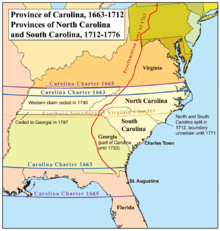
On March 24, 1663, Charles II issued a new charter to a group of eight English noblemen, granting them the land of Carolina, as a reward for their faithful support of his efforts to regain the throne of England.
In 1729 the Province of Carolina was divided when the descendants of seven of the eight Lords Proprietors sold their shares back to the Crown.
[10] North Carolina was also a key Confederate state, raising and supplying many regiments of soldiers to the Confederacy.
[12] North Carolina's Civil War governor, Zebulon Vance, was an outspoken critic of Confederate President Jefferson Davis and frequently refused to obey Davis's orders for reinforcements and supplies; Vance insisted the soldiers and supplies would be needed for North Carolina's Confederate effort.
However, during the seven days' battles, North Carolina did send large numbers of troops for the general aid of the South as a whole.
In South Carolina, no Union Army regiments were formed due to a smaller unionist presence, although the Upstate region of the state was a haven for Confederate Army deserters and resisters, as they used the Upstate topography and traditional community relations to resist service in the Confederate ranks.
In 1947, the journalist John Gunther wrote, "that North Carolina is by a good deal the most progressive Southern state will, I imagine, be agreed to by almost everybody.
The predominance of certain crops would help influence the regional economy: Like other [Southern] states, until after World War II, North Carolina remained primarily a region of small farms and factories heavily dependent on just a few labor-intensive crops, relying on sharecropping and tenancy, especially for black laborers.
As mechanization increased in farming, along with textiles, apparel, and furniture jobs shifting because of globalization, combined with the decline of the tobacco industry,[23] many rural and small urban communities suffered economically.
Charlotte is headquarters to several major publicly traded corporations such as Bank of America, Truist Financial, and the East Coast operations of Wells Fargo, and Centene Corporation, as well as six other Fortune 500 companies, including Lowe's, Duke Energy, Nucor, Honeywell, Brighthouse Financial, and Sonic Automotive.
However, only the North Carolina team returned at that time, extending the line northwest 70 miles (110 km).
[29] Joseph Caldwell, president of the University of North Carolina at Chapel Hill, found that the line west of the Pee Dee did not run along the 35th parallel, but 12 miles (19 km) to the south.
[30] In the mid-1990s, Duke Power determined that the border between the Carolinas needed to be re-surveyed, as the company was selling and donating land in the Jocassee Gorge area, which included parts of both states.
[29] Also, with more people living outside cities, the precise boundaries of fire, tax, and school district lines needed to be known.
[29] South Carolina had recently been involved in a costly legal battle with Georgia over a small number of islands in the Savannah River, and wanted to avoid the expense of a lawsuit regarding the North Carolina border, so the two states agreed in 1993 to cooperate in resurveying the border.
[32] The Joint Boundary Commission met in February 2014 in Monroe, North Carolina, to determine what actions still needed to be taken.
Legislative action could allow people to keep utilities, avoid back taxes to the new state, and continue in the same schools.
Lake Wylie Minimarket could be grandfathered, or Congress could change the defined border at the store's location, though the commission intended to avoid such an action.
[41][42] On December 9, 2016, McCrory announced that he signed a four-page executive order formally defining the border between the two states based on the 20 years of work.
After the NHL-WHA merger in 1979, they joined the NHL as the Hartford Whalers until 1997 when they relocated to Raleigh, North Carolina.