Great Wagon Road
The heavily traveled Great Wagon Road was the primary route for the early settlement of the Southern United States, particularly the "backcountry".
The German Palatines and Scotch-Irish immigrants arrived in huge numbers because of bloody religious conflicts and persecution of Protestants by monarchies in Great Britain and Europe.
The mostly Protestant German Palatines (also known as Pennsylvania Dutch) tended to find rich farmland and work it zealously to become stable and prosperous.
The other group, mostly Protestant Presbyterians known as Scotch-Irish, tended to be restless, clannish, fiercely independent, and hosted a centuries old animosity to the British Crown.
[1][2][3] Beginning at the port of Philadelphia, where many immigrants entered the colonies, the Great Wagon Road passed through the towns of Lancaster and York in southeastern Pennsylvania.
Turning southwest, the road crossed the Potomac River and entered the Shenandoah Valley near present-day Martinsburg, West Virginia.
From Big Lick/Roanoke, after 1748, the Great Wagon Road passed through the Maggoty Gap (also called Maggodee) to the east side of the Blue Ridge Mountains.
The Great Wagon Road ultimately reached Augusta, Georgia, on the Savannah River, a distance of more than 800 miles (1,300 km) from Philadelphia.
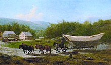
Although there surely would have been pleasant areas for travel, road conditions also could vary from deep mud to thick dust, mixed with animal waste.
In 1758 the Forbes military wagon road was built, branching west from Chambersburg to Fort Loudon, Pennsylvania, and on to Pittsburgh.
Heavy wagon traffic carried supplies from Philadelphia through Lancaster and Harrisburg to the General Forbes army, which was based in Carlisle.
)[19] Much later, in 1806, a group of Conestoga wagon craftsmen moved from Lancaster to the Harrisburg area where they set up business; the settlement was named Mechanicsburg in 1820 because of all their shops there.
This route bypassed Chambersburg and Fort Loudon, saving considerable toll and forage expenses for Conestoga wagon teamsters traveling between Philadelphia and Pittsburgh.
[39] The Forbes military wagon road (now US-30), built in 1758 to attack the French, branched west from Chambersburg through Fort Loudon and McConnellsburg to present-day Pittsburgh.
Fifteen Moravian settlers, traveling with a large wagon, noted that they passed by the tavern and stopped briefly at the "German" inn on October 16, 1753; they were on their way from Bethlehem, Pennsylvania, to Wachovia (now Winston-Salem), North Carolina.
VA-613 leaves the Great Valley, crossing into Franklin County through Maggoty Gap in the Blue Ridge Mountains; this route provided wagon access to North and South Carolina and Georgia.
He owned the land on both sides of the road approaching the ford from the east and was already operating a tavern here in 1753, which also served travelers for many years thereafter.
[106] Shallow Ford itself is a gravel bar below a natural stone ledge, smooth, wide and flat, and capable of supporting large heavy wagons and automobiles.
In 1770, another road was ordered cut west to "Mulberry Fields" (now Wilkesboro), which was extended later to Kentucky as the "Daniel Boone Trail" and which turned Shallow Ford into a major north-south and east-west crossroad.