Caroline Island
It is home to one of the world's largest populations of the coconut crab and is an important breeding site for seabirds, most notably the sooty tern.
A 1995 realignment of the International Date Line made Caroline Island the first point of land on Earth to reach 1 January 2000 on the calendar.
[3] There are indications that early Polynesians reached the island before Europeans, as several marae (communal or sacred places) and graves have been discovered, but no evidence has been found of long-term settlement.
[6] The island was next seen by Europeans on 16 December 1795, when the British naval officer William Robert Broughton of HMS Providence named it Carolina, after the daughter of Philip Stephens, the First Secretary of the Admiralty.
[4] Other early visits which left behind accounts of the island include that of the USS Dolphin in 1825, written by the United States Navy officer Hiram Paulding.
On 22 March, American and English astronomers left the Peruvian port of Callao aboard the USS Hartford, arriving at the island on 20 April.
[14] As small boats could not come close to the shore, the equipment was carried to the island by men standing in about 2 feet (0.6 m) of water, and then about 500 yards (460 m) further to the observation site.
[18] The Austrian astronomer Johann Palisa, a member of the French expedition, discovered an asteroid later that year, which he named Carolina after the island.
[19] In 1846, the Tahitian firm of Collie and Lucett attempted to establish a small stock-raising and copra-harvesting community on the island; the operation met with limited financial success.
[41] Other Pacific nations, including Tonga, New Zealand and Fiji, protested the move, objecting that it infringed on their claims to be the first land to see dawn in the year 2000.
[42] According to the United States Naval Observatory, the first point of land to see sunrise on 1 January 2000 (local time) was between the Dibble Glacier and Victor Bay in East Antarctica, at 66 degrees south, where the sun rose at 12:08 a.m.[43] In August 1997, to promote events to mark the arrival of the year 2000, Caroline Island was renamed Millennium Island by the Kiribati government.
[44] In December 1999, over 70 Kiribati singers and dancers travelled to Caroline from South Tarawa, accompanied by approximately 25 journalists, as part of the celebrations to mark the arrival of the new millennium.
[45] In 2017 a Russian businessman proposed a deal to invest $350 million to build a resort in Kiribati in exchange for sovereign rights over three islands.
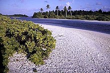
[50] The islets—which rise to a height of 6 m (20 ft) above sea level[51]—share a common geologic origin, and consist of sand deposits and limestone rock set atop a coral reef.
[59][60] The lagoon, roughly 6 by 0.5 km (3.73 by 0.31 mi) in size,[3] is shallow—it is at most 8.8–13.7 m (29–45 ft) in depth[61]—and is crossed repeatedly by narrow coral heads and patch reefs.
[64] Soils are of poor quality, dominated by coral gravel and sand, with organic content present only within stable, forested island centers.
[69] Tides are on the order of 0.5 m (1.6 ft),[70] and trade winds, generally from the northeast, mean that corner of the island experiences the roughest seas.
The English naturalist and geologist Charles Darwin first suggested the theory, still accepted, that atolls originate from calcium carbonate platforms that grow around the cones of extinct, sinking volcanoes.
In 1972, the American geophysicist W. Jason Morgan postulated that the chain was formed 70 myr ago in parallel with the creation of the Hawaiian Islands, each by means of a single hotspot.
Other experts argued against this model, pointing to geometric and paleomagnetic evidence, and the complex timing of the volcanic episodes that created the Line Island chain.
[75] Over the next decade it was discovered that Late Cretaceous and Eocene volcanism had occurred close to Caroline Island, as well as thousands of kilometres to the north, which disproved the single hotspot model for the formation of the Line Islands, and instead suggested the chain was made by a more complex series of volcanic events than the Hawaiian–Emperor seamount chain.
[93] In 2014 the Kiribati government established a fishing exclusion zone extending to 12 nautical miles around each of the southern Line Islands—Caroline, Flint, Vostok, Malden, and Starbuck.
Other native animals include the Tridacna clam, which is abundant in the central lagoon, hermit crabs, and multiple species of lizards.
[93] Human contact has caused the introduction of about twenty non-native species of flora to Caroline Island, including the vine Ipomoea violacea, which has begun to proliferate.
Domestic cats and dogs introduced alongside a small homestead have driven the seabird population away from the islet of Motu Ana-Ana.
[3] The introduced coconut palm is a highly competitive plant which blocks the light and so prevents other species from growing, but is only prevalent on South Islet.