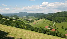
Central Black Forest
It generally refers to a region of deeply incised valleys from the Rench valley and southern foothills of the Kniebis in the north to the area of Freiburg im Breisgau and Donaueschingen in the south.
Its highest area, which is southeast of the Elz valley, is also part of the High Black Forest.
[1] The dominating valley system of the Kinzig cuts through the Middle Black Forest from east to west.
Prominent peaks are the Kandel (1,241 m), Weißtannenhöhe (1,190 m), Obereck (1,177 m), Rohrhardsberg (1,152 m), Brend (1,149 m), Stöcklewald (1,067 m) and Mooswaldkopf (887 m) south of the Kinzig, and the Brandenkopf (945 m) and Lettstädter Höhe (960 m) north of the Kinzig.
Unlike the Northern Black Forest the Bunter sandstone covering with its plateau-like mountain shapes has only survived in a few places on the eastern perimeter.