Kinzig (Rhine)
In addition, the question remains of how far the Celts or Pre-Celts had settled the Kinzig area, and which settlers had originally given the river its name.
While these questions are difficult to answer for pre-historic times, the fact is that the Kinzig only created a small canyon in its upper part.
At the end of the last ice age it wound its way through the Plains for a long time, on the way absorbing the Murg and only joining the Rhine after it reached the general area of Hockenheim.
In the Black Forest many tributaries empty into the Kinzig, including several longer streams of 20-30 kilometres in length, most coming from the north or south.
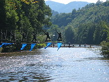
They were given the sole rights of timber export by their respective overlords and ran a lucrative business that helped the towns' prosperity.
Sebastian Münster writes in his Cosmographia universalis: "The people living by the River Kyntzig, especially around Wolfach, earn a living from the great quantity of construction timber, which the float down the waters of the Kyntzig to Strasburg and into the Rhine, and earn a great deal of money every year."
The width, length and the favourable east-west direction of the middle and lower valley of the Kinzig make it important for as a communication route.
The Kinzigtalstraße was a military road built under Emperor Vespasian in 73/74 AD from Offenburg through the Kinzig Valley into the Roman Rottweil (Arae Flaviae) and on to Tuttlingen.
Until this road was built, the connection took troops via the Rhine bend at Basel and during the revolt of the Batavers in 69/70 AD, this had proved to be a problem.
In addition to Rottweil, the rest areas in Offenburg-Rammersweier, Offenburg-Zunsweier, Waldmössingen, Sulz and Geislingen-Häsenbühl, were augmented by part of the Alb Limes fortifications in Frittlingen, Lautlingen and Burladingen-Hausen.
Roughly at the same time that the Kinzigtalstraße was built, Roman forts were constructed further north on the right side of the Rhine in places like Frankfurt, Heddernheim, Karben, Groß-Gerau, Gernsheim, Ladenburg (Lopodunum), Heidelberg and Baden-Baden (Aquae).
Whether these were advanced posts or the Roman border between 73 and 98 AD, (following a generally defined line east of the Rhine), has yet to be determined.
In 98 AD, in the area of present-day southwest Germany, the route between Odenwald and Neckar came under Roman control, making the connection from Mainz to Augsburg shorter yet.