Central Valley Project
In addition to water storage and regulation, the system has a hydroelectric capacity of over 2,000 megawatts, and provides recreation and flood control with its twenty dams and reservoirs.
Freshwater stored in Sacramento River reservoirs and released downriver during dry periods prevents salt water from intruding into the Sacramento-San Joaquin Delta during high tide.
California agriculture and related industries now directly account for 7% of the gross state product for which the CVP supplied water for about half.
Many CVP operations have had considerable environmental consequences, including a decline in the salmon population of four major California rivers in the northern state, and the reduction of riparian zones and wetlands.
In recent years, a combination of drought and regulatory decisions passed based on the Endangered Species Act of 1973 have forced Reclamation to turn off much of the water for the west side of the San Joaquin Valley in order to protect the fragile ecosystem in the Sacramento-San Joaquin Delta and keep alive the dwindling fish populations of Northern and Central California rivers.
In 2017 the Klamath and Trinity rivers witnessed the worst fall run Chinook salmon return in recorded history, leading to a disaster declaration in California and Oregon due to the loss of the commercial fisheries.
Only 1,123 adult winter Chinook salmon returned to the Sacramento Valley in 2017, according to a report sent to the Pacific Fishery Management Council (PFMC) by the California Department of Fish and Wildlife (CDFW).
Finally, New Melones Lake, a separate facility, stores water flow of a San Joaquin River tributary for use during dry periods.
The Central Valley of California lies to the west of the Sierra Nevada Mountains with its annual run-off draining into the Pacific Ocean through the Sacramento–San Joaquin River Delta.
It is a large receding geological floodplain moderated by its Mediterranean climate of dry summers and wet winters that includes regular major drought cycles.
Then came the arrival of Europeans, first by the Spanish colonial model of Catholic missions and ranchos (1772–1846) was then followed by the current United States era.
Spain's model of land use with the grazing of livestock for meat, wool and leather started along Alta California's coast eventually spreading inland.
The U.S. era evolved from primarily ranching to large-scale plantations or more commonly known today as corporate farming that turned the Central Valley into the breadbasket of the U.S.
[3] In 1873, Barton S. Alexander completed a report for the U.S. Army Corps of Engineers that was the first attempt at creating a Central Valley Project.
[3] Unfortunately, because of insufficient money in the state's treasury and the coincidence with the Great Depression, California turned to the national government for funding to build the project.
[3] Dec 2 - USBR regulations stipulate that water only be given out to farmers with 160 acres of land or less - see 4-7-1944 1951 Jan 3 - CVP and state agree to keep grasslands flooded to protect migratory birds[321] Shasta Division consists of a pair of large dams on the Sacramento River north of the city of Redding.
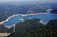
These include Sugar Pine Dam and Pipeline (supplying water to Foresthill), and the uncompleted Folsom South Canal.
[578] The primary component of the unit, concrete thin-arch Auburn Dam, was to be located on the North Fork of the American, but was never built because of the significant risk of earthquakes in the area, and general public opposition to the project.
[582] The CVP also has several dams on the San Joaquin River—which has far less average flow than the Sacramento—in order to divert its water to southern Central Valley aqueducts.
[583] The Central Valley also consisted of 500 miles of canals, providing the city dwellers and power sales from the generation of electricity pay of the project costs.
[585] On the Stanislaus River, a major tributary of the San Joaquin, lies the relatively independent East Side Division and New Melones Unit of the CVP.
[586][588] The CVP has a significant amount of facilities for storing and transporting water on the west side of the San Joaquin Valley, in the foothills of the California Coast Ranges.
Downstream of San Luis Reservoir is O'Neill Forebay, which is intersected by the Delta-Mendota Canal, a separate CVP facility.
[589] The CVP also operates a San Felipe Division to supply water to 63,500 acres (25,700 ha) of land in the Santa Clara Valley west of the Coast Ranges.
In the early years of the 21st century, the Bureau of Reclamation finally began to steadily increase the water flow downstream from Lewiston Dam.
[603] One of the proposed heights was 18.5 feet (5.6 m) greater than its current size, thus increasing the storage capacity of Shasta Lake by 636,000 acre-feet (784,000 dam3).
When Shasta Dam was first built, it was actually planned to be two hundred feet higher than it is now, but Reclamation stopped construction at its present height because of a shortage of materials and workers during World War II.
The raising of the dam would further regulate and store more Sacramento River water for dry periods, thus benefiting the entire operations of the CVP, and also generating additional power.
Originally, after the dam was constructed, the State of California put filling the reservoir on hold because of enormous public opposition to what was being inundated: the limestone canyon behind the dam, the deepest of its kind in the United States, contained hundreds of archaeological and historic sites and one of California's best and most popular whitewater rafting runs.
[608] In response to these environmental problems, Congress passed in 1992 the Central Valley Project Improvement Act (CVPIA), Title 34 of Public Law 102-575, to change water management practices in the CVP in order to lessen the ecological impact on the San Joaquin and Sacramento Rivers.