Central Valley (California)
It provides a large share of the food produced in California, which provides more than half of the fruits, vegetables, and nuts grown in the United States.
[4] The valley hosts many cities, including the state capital Sacramento, as well as Redding, Chico, Stockton, Modesto, Merced, Fresno, Visalia, Porterville, and Bakersfield.
The valley encompasses all or parts of 18 California counties: Butte, Colusa, Glenn, Fresno, Kern, Kings, Madera, Merced, Placer, San Joaquin, Sacramento, Shasta, Stanislaus, Sutter, Tehama, Tulare, Yolo and Yuba.
The following metropolitan and micropolitan statistical areas are listed from largest to smallest: After English and Spanish, Punjabi is the third most commonly spoken language in the Central Valley.
Before California's flood control and aqueduct system was built, annual snow melt turned much of the valley into an inland sea.
The one notable exception to the flat valley floor is Sutter Buttes, the remnants of an extinct volcano just to the northwest of Yuba City.
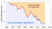
[11][12] Excessive groundwater pumping in Central Valley has caused measurable amounts of land subsidence in recent years.
However, much of the Central Valley environment has been altered by human activity, including the introduction of exotic plants, notably grasses.
Grassland flowers include California poppy (Eschscholzia californica), lupins, and purple owl's clover (Castilleja exserta), which can still be seen, especially in Antelope Valley in the Tehachapi Mountains.
Riverside trees include willows, western sycamore (Platanus racemosa), box elder (Acer negundo), Fremont cottonwood (Populus fremontii), and the endemic valley oak (Quercus lobata).
[15] The Central Valley was once home to large populations of pronghorn antelope (Antilocapra americana), elk including the endemic tule elk subspecies (Cervus elaphus nannodes), mule deer (Odocoileus hemionus), California ground squirrels, gophers, mice, hare, rabbits and kangaroo rats, along with their predators including the San Joaquin kit fox (an endangered subspecies surviving on the San Joaquin Valley's hillsides).
Remaining vernal pools include Pixley National Wildlife Refuge between Tulare, California, and Bakersfield and Jepson Prairie Preserve in the delta.
Most of the grassland has been overtaken by new species; most vernal pools have been destroyed, leaving only those on the higher slopes; the marshland has been drained, and the riverbank woodlands have nearly all been affected.
The soil exudes nitrous oxide, an odorless and colorless gas that can be harmful when exposed to it for a long period of time, and incorporates itself into the ozone layer located at ground level.
Long term effects that nitrous oxide can have on a human being is loss of blood pressure, fainting, anemia, or lung cancer.
The Central Valley is surrounded by mountain ranges which can capture the pollution coming from the agricultural farming, preventing it from dispersing from the other areas in California.
In the southern part of the San Joaquin Valley, the alluvial fan of the Kings River and another from Coast Ranges streams have created a divide.
The dry Tulare basin of the Central Valley receives flow from four major Sierra Nevada rivers, the Kings, Kaweah, Tule, and Kern.
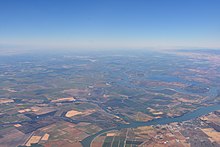
[34] Central Valley rivers converge in the Sacramento-San Joaquin Delta, a network of marshy channels, distributaries, and sloughs that wind around islands mainly used for agriculture.
[40] Post-World War II demand for urban development, most notably the San Francisco Bay Area and the Los Angeles/Inland Empire/San Diego, required water resources.
The Kings, Kaweah, Tule and Kern rivers originally flowed into these seasonal lakes, which would expand each spring to flood large parts of the southern San Joaquin Valley.
Farms, towns, and infrastructure in these lakebeds are protected with levee systems, while the risk of floods damaging properties increased greatly.
Changes in climate and precipitation levels have shown that consistent average rainfall has increased the number and intensity of landslides within the past 5–6 years.
Quick-moving landslides are caused by very intense rain, or sometimes earthquakes, that make a greater difference in the land in a shorter amount of time.
According to a survey paper written in 1988 about a storm that occurred in 1982 in the Central Valley region, rainstorms that can cause that type of landslide to happen about every 5 years.
This intense storm in the San Francisco Bay area caused a lot of damage as a result of moving debris and landslides.
Despite state hiring cutbacks and the closure of several military bases, Sacramento's economy has continued to expand and diversify and now more closely resembles that of the San Francisco Bay Area.
Primary sources of population growth are Bay Area migrants seeking lower housing costs, augmented by immigration from Asia, Central America, Mexico, Ukraine, and the rest of the former Soviet Union.
[52] Virtually all non-tropical crops are grown in the Central Valley, which is the primary source for produce throughout the United States, including tomatoes, grapes, cotton, apricots, and asparagus.
In the 1960s, farm labor leaders Cesar Chavez and Dolores Huerta organized Mexican American grape pickers into a union, the National Farmworkers Association (NFWA), to improve their working conditions.