Cerro Autana
Cerro Autana (Wahari-Kuawai ) plays the role of the "tree of life" in the oral history and lore of the Piaroa Indians who inhabit the region.
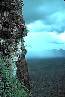
Cerro Autana like other table-top mountains in the region is the remains of a large sandstone plateau that once covered the granite basement complex between the north border of the Amazon Basin and the Orinoco, between the Atlantic coast and the Rio Negro.
The table-mountain topography is formed as water percolates along joints and bedding planes, the siliceous cement dissolves, quartzite disaggregates, and large blocks collapse which accumulate in the foot of the scarps.
The percolating water forms large and intricate cave systems, which frequently emerge in the scarp zone as high waterfalls.
This process leaves large empty spaces which in Cerro Autana form interconnected caverns and a lounge with a domed ceiling.
A particular alumino-nitrate found in the main cave is sveite, named after the Sociedad Venezolana de Espeleologia whose members collected the first samples.
Typical of other tepui formations, the open rock surfaces are inhabited by collections of plant communities which include algae, lichens, mosses and low herbs.
Piaroan mythology tells how '-the tree-top went as high as the infinite, and its branches were full of fruits which fell and gave life to the Amazon'.