Chandrayaan-1
India launched the spacecraft using a PSLV-XL rocket on 22 October 2008 at 00:52 UTC from Satish Dhawan Space Centre, at Sriharikota, Andhra Pradesh.
On 14 November 2008, the Moon Impact Probe separated from the Chandrayaan orbiter at 14:36 UTC and struck the south pole in a controlled manner.
[22] After almost a year, the orbiter started experiencing several technical issues including failure of the star tracker and poor thermal shielding; Chandrayaan-1 stopped communicating at about 20:00 UTC on 28 August 2009, shortly after which the ISRO officially declared that the mission was over.
Chandrayaan-1 operated for 312 days as opposed to the intended two years; however, the mission achieved most of its scientific objectives, including detecting the presence of Lunar water.
[59] The fifth and final orbit raising manoeuvre was carried out on 3 November 2008 at 23:26 UTC when the spacecraft's engine was fired for about two and a half minutes resulting in Chandrayaan-1 entering the Lunar Transfer Trajectory with an apogee of about 380,000 km (240,000 mi).
This manoeuvre involved firing of the liquid engine for 817 seconds (about thirteen and half minutes) when the spacecraft passed within 500 km (310 mi) from the Moon.
[66] The Moon Impact Probe (MIP) crash-landed on the lunar surface on 14 November 2008, 15:01 UTC near the crater Shackleton at the south pole.
[67] The MIP separated from Chandrayaan at 100 km from the lunar surface and began its nosedive at 14:36 UTC, going into free fall for thirty minutes.
The altimeter then also began recording measurements to prepare for a rover to land on the lunar surface during a second Moon mission.
[67] After scientific analyses of the received data from the MIP, the Indian Space Research Organisation confirmed the presence of water in the lunar soil and published the finding in a press conference addressed by its then Chairman G. Madhavan Nair.
[73][74] The mineral content on the lunar surface was mapped with the Moon Mineralogy Mapper (M3), a NASA instrument on board the orbiter.
[76] ISRO announced in January 2009 the completion of the mapping of the Apollo Moon missions landing sites by the orbiter, using multiple payloads.
Afterward, the orientation of Chandrayaan was determined using a back-up procedure using a two-axis Sun sensor and taking a bearing from an Earth station.
[96] In March 2010, it was reported that the Mini-SAR on board the Chandrayaan-1 had discovered more than 40 permanently darkened craters near the Moon's north pole which are hypothesized to contain an estimated 600 million metric tonnes of water-ice.
[100] ISRO Chairman G. Madhavan Nair said that due to very high radiation, power-supply units controlling both the computer systems on board failed, snapping the communication connectivity.
The Bulgarian payload called Radiation Dose Monitor (RADOM) was activated on the day of the launch itself and worked until the mission's end.
[107] ISRO said scientists from India and participating agencies expressed satisfaction on the performance of Chandrayaan-1 mission as well as the high quality of data sent by the spacecraft.
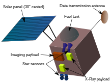
[109] In its 10-month orbit around the Moon, Chandrayaan-1's X-ray Spectrometer (C1XS) detected titanium, confirmed the presence of calcium, and gathered the most accurate measurements yet of magnesium, aluminium and iron on the lunar surface.
During its 25 minute descent, Chandra's Altitudinal Composition Explorer (CHACE) recorded evidence of water in 650 mass spectra readings gathered during this time.
On the Moon, the feature is seen as a widely distributed absorption that appears strongest at cooler high latitudes and at several fresh feldspathic craters.
OH/H2O production processes may feed polar cold traps and make the lunar regolith a candidate source of volatiles for human exploration.
M3 data were reanalyzed years later and revealed "the most definitive proof to date" of the presence of water in shaded regions of craters near the Moon's north and south poles.
"The Moon, in fact, has water in all sorts of places; not just locked up in minerals, but scattered throughout the broken-up surface, and, potentially, in blocks or sheets of ice at depth."
"[117][118] According to European Space Agency (ESA) scientists, the lunar regolith (a loose collection of irregular dust grains making up the Moon's surface) absorbs hydrogen nuclei from solar winds.
[119] The SARA (Sub keV Atom Reflecting Analyser) instrument developed by ESA and the Indian Space Research Organisation was designed and used to study the Moon's surface composition and solar-wind/surface interactions.
This knowledge provides timely advice for scientists who are readying ESA's BepiColombo mission to Mercury, as that spacecraft will carry two instruments similar to SARA.
[121] The tunnel, which was discovered near the lunar equator, is an empty volcanic tube, measuring about 2 km (1.2 mi) in length and 360 m (1,180 ft) in width.
According to A. S. Arya, scientist SF of Ahmedabad-based Space Application Centre (SAC), this could be a potential site for human settlement on the Moon.
[123] Data from the microwave sensor (Mini-SAR) of Chandrayaan-1 processed using the image analysis software ENVI, has revealed a good amount of past tectonic activity on the lunar surface.
[136] A third mission, called Chandrayaan-3 was launched on 14 July 2023 and it successfully soft-landed on Moon on 23 August 2023[137] Chandrayaan's imagery will be used to identify regions of interest that will be explored in detail by the NASA Lunar Reconnaissance Orbiter.