Chaos Crags
The cluster of domes is located north of Lassen Peak and form part of the southernmost segment of the Cascade Range in Northern California.
Geological study of the Chaos Crags, which continues today, began in the late 1920s, when Howel Williams wrote about its pyroclastic rock deposits, rockfall avalanches, and eruptions.
[7] Known as the Crags Lake[8] or the Chaos Crater,[9] it forms in a depression that acts as a basin to collect melted snow during the spring season.
[3] All three sequences — Bumpass, Eagle Peak, and Twin Lakes — formed from lava subjected to magma-mixing processes, accounting for their heterogeneous appearance and composition.
[11] The Chaos Crags consist of five small lava domes, made of rhyodacite,[14] which line up with the western edge of the Mount Tehama caldera.
[22] Six domes were originally formed, though after 70 years of quiescence, one was destroyed by a violent eruption[14][18] that produced a pyroclastic flow[23] and tephra deposits that can be detected in Manzanita and Lost Creeks.
Pumice from the eruption has high phenocryst content,[22] with crystals of plagioclase, hornblende, biotite, quartz, and magnetite;[12] it also has low vesicularity values.
[34] The Chaos Jumbles deposits from the collapsed dome consist of lobed, non-bedded coarse to fine rubble, with blocks reaching widths of 16 feet (5 m).
"[35] Pyroclastic flows and avalanches from the formation reached the areas where parts of the Manzanita Lake visitor center facilities now reside.
[35] If the Chaos Crags resumed activity, they could erupt pumice, pyroclastic flows, or swift rockfalls, in addition to creating lava domes, though these would not pose major threats to human life should the surrounding area be evacuated promptly.
[36] These pyroclastic flows could reach regions directly surrounding the eruptive volcanic vent, and would extend at least 9.3 miles (15 km) into the nearby valley floors.
However, given the sudden nature of rockfall-avalanches, these would be more dangerous than pyroclastic flows or tephra, as they could occur without warning, seriously endangering life within 3.1 miles (5 km) of the Crags.
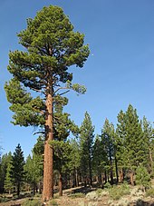
[43] Other plants found in the area consist of coyote mint, lupines, mule's ears, ferns,[44] corn lilies, red mountain heathers,[45] pinemat manzanitas,[46] greenleaf manzanitas, bush chinquapins,[42] catchflies, Fremont's butterweed, buckwheat, granite gilia, mountain pride, mariposa tulips, creambush,[47] and a variety of chaparral shrubs.
[48] In forested areas below 7,800 feet (2,400 m), animals include American black bears, mule deer, martens, brown creepers, mountain chickadees, white-headed woodpeckers, long-toed salamanders, and several bat species.
At higher elevations, Clark's nutcrackers, deer mice, and chipmunks can be found among mountain hemlock stands, and subalpine zones with sparse vegetation host populations of gray-crowned rosy finches, pikas, and golden-mantled ground squirrels.
Among scattered stands of pinemat manzanita, red fir, and lodgepole pine, animals include dark-eyed juncos, montane voles, and sagebrush lizards.
Meadows at the bottoms of valleys along streams and lakes support Pacific tree frogs, Western terrestrial garter snakes, common snipes, and mountain pocket gophers.
[1] Geological study of the Chaos Crags began in the late 1920s, when Howel Williams wrote about its pyroclastic rock deposits, rockfall avalanches, and the dome-producing eruptions.
[55] In 1974, the National Park Service closed the visitor center and accommodations at Manzanita Lake, fearing that these buildings would be in the way of a rockslide from Chaos Crags if an earthquake or volcanic eruption occurred in the area.
[56] In 2011, twenty wooden cabins, along with picnic tables, fire rings, and food lockers, were reinstalled in the Manzanita Lake Campground.
[17] Gaining 850 feet (260 m) in elevation,[7] the trail offers views of the Jumbles, the Crags, and the pyroclastic flow deposits,[17] in addition to the Hat Creek valley and the Thousand Lakes Wilderness.