Chapel-le-Dale (valley)
However, some older texts insist the name of the watercourse through the dale is the River Greta, which runs from a point below the hamlet of Chapel-le-Dale, and onwards past Ingleton.
[9] It was later improved as part of the Richmond to Lancaster Turnpike,[10] and before dropping down into Ribblehead, reaches a height of 323 metres (1,059 ft).
[14] The Domesday Book records the whole area around Selside, Ribblesdale, Clapham, Newby and Chapel-le-Dale as being held by Thorfin of Ravensworth.
[16][17] By the 12th century, the vaccaries (Medieval cattle farms) at Southerscales, Querneside (Whernside), and Winterscales, were in the possession of Furness Abbey.
[18] An assessment of the estates held by Furness in 1535 (just before the Dissolution) estimated that Upper Ribblesdale and Chapel-le-Dale were rated as being £76 and 9 shillings (equivalent to £59,000 in 2023).
[28] Walking is a popular past-time through the dale; in 1887 two Giggleswick schoolmasters inadvertently created the Three Peaks Challenge by climbing Ingleborough and seeing the good weather, descended through Chapel-le-Dale to Whernside, and later Pen-y-ghent.
One book, which discusses the prevalence of caving areas in Upper Gretadale (Weathercote Cave, Gingle Pot, Hurtle Pot, Gatekirk),[40] describes the upper waters as Chapel Beck, and what is annotated on OS mapping as the River Doe, is described as the River Greta.
[36] The River Doe runs for 6 kilometres (3.7 mi), and has the Beezley and Snow Falls waterfalls on its lower reaches.
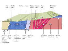
[52] Ice carved out the Yorkshire Dales in the Anglian, Wolstonian and the Devensian stages of geological history.
[70] The rock on the basement floor of the valley has no trace of fossilisation, so they were assumed to be of Precambrian age, however, carbon dating has shown them to be some 480 million years old, making them part of the Ordovician era.
[77] Scales Moor possesses some of the "finest examples of horizontal [limestone] pavements in Britain, and include some massive undissected clints.
[88][89] In times of great rainfall and flood, the river does travel overground, around the chapel and emerges at God's Bridge, however, for the most part, this riverbed is dry.
[97][98] The greywacke is a "steeply folded hard sandstone that cleaves like slate..", and is dug out of a hole that extends to a depth of 130 metres (430 ft).
[104] Meal Bank Quarry is designated as a scheduled monument and an SSSI due to the geology located there, which includes a layer of coal, the thickest of its kind in a British marine limestone occurrence.
[109] In August 2016, the White Scar Caves complex was closed due to extreme flooding from underground which swept through the visitor centre and poured down the steps making the B6255 road almost impassable.
[110] In 1800, John Housman travelled up Kingsdale and across Scales Moor, standing at the head of the dale, and due to its well-rained and farmed nature between the two peaks of Whernside and Ingleborough, he said that it looked like "a green strip of cloth connecting two webs of the coarseth [sic] cloth.
"[111] The only notable settlement is the hamlet of Chapel-le-Dale which is 4 miles (6.4 km) north-east of Ingleton, and 240 metres (800 ft) above sea level.
[122][123] Farms exist on the upper northern side of the dale at Broadrake, Bruntscar, Gunner Fleet, Ivescar, and Winterscales.
The actual date of its founding is uncertain, however a reader is mentioned in the parish records for Ingleton Fells (an early name for the Chapel-le-Dale area) in 1666.
[138] Since 1991, access to the Battlefield cavern has been provided (which is 1.5 kilometres (0.93 mi)) in, by a team of Cornish tin miners who blasted away the rock.
[141] The presence of so many caves and waterfalls in the dale led to Harry Speight labelling it as one of the "wonders of Yorkshire".
There was no body inside the coffin, but it did contain an Indian takeaway meal, reams of computer tape and "a large number of Co-Op stamps..".
After other finds, including a litter bin and a model dinosaur wedged down potholes, the landlord of the Old Hill Inn blamed the caving community.
[149] The SSSI to the west of the Ingleton Quarry has a very rare species of moss - Thamnobryum cataractarum, known as Yorkshire Feather-moss.