Ingleton, North Yorkshire
[2] Arthur Conan Doyle was a regular visitor to the area and was married locally, as his mother lived at Masongill from 1882 to 1917 (see notable people).
[3] Whernside, 6 miles (9.7 km) north-north-east of the village, one of the Yorkshire Three Peaks, is the highest point in the parish at 736 metres (2,415 ft).
There was a textile mill, and the coalfield supported twelve or more small collieries, but Ingleton is mostly known for its tourism, being partially in the Yorkshire Dales National Park, offering waterfalls in a SSSI, limestone caves and Karst landscape walking opportunities.
Ingleton and the surrounding area was settled in the Iron Age by the Brigantes who built a hill fort on top of Ingleborough with walls 0.6-mile (1 km) in circumference.
[5] Willian Lowther (1574–1641) of Ingleton Hall was Lord of the Manor, Justice of the Peace for the West Riding and had seven children.
His daughter Frances (1612–1665) married John Walker who leased the Ingleton Colleries, and Elizabeth (1615–?)
The war ended and his father dead, Gerrard was fined by the new government for his delinquency, and entered into a series of agreements to pay the debt and court appearances to maintain the estate.
Thomas Moore (?–1733) was the second husband of Marianne Walker and between 1702 and 1711 bought out other share holders in the collieries while building a successful medical practice in Wakefield.
Plans were drawn up in 1780 to connect Ingleton to the Leeds & Liverpool Canal via Clapham, Settle and Foulridge, Colne but it never progressed.
[16] The village is a part of the Ingleton & Clapham ward of Craven District Council and returns two members.
[1] The village is within the Skipton and Ripon parliamentary constituency, represented by Julian Smith, a member of the Conservative Party, as of the 2010 general election.
It passes due south over Ingleborough Common to Newbury Moss, descending to Cold Cotes on the old road at SD 722712.
[19] The village sits at the foot of Ingleborough, separated from Thornton-in-Lonsdale by the Rivers Greta and Twiss, some of the facilities that form the settlement being thus outside the civil parish.
The peaks of Ingleborough and Whernside lies within the parish; separated by the deeply eroded valley of the River Doe.
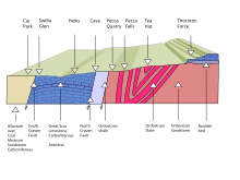
[21] A varied geology is found within the boundaries of the parish, ranging from rocks laid down in the Iapetus Ocean in Ordovician times, through the Carboniferous limestones of the Askrigg Block on Whernside and Ingleborough and coal measures within the Craven Basin, to the Quaternary drumlin field in Ribblehead.
[25] The lower Carboniferous deposits are dominated by the 200 metres (660 ft) thick Great Scar limestones laid down during the Viséan stage.
[26] Scales Moor on the Whernside flanks of Chapel-le-Dale has one of the largest exposures of pavement in the Dales, measuring some 4 kilometres (2.5 mi) long 800 metres (870 yd) wide.
[28] The upper ramparts of these hills are capped by thick beds of Grassington Grit, a course poorly-sorted sandstone laid down in shallower water as the delta prograded south.
[30] Just to the north of Ingleton village the Craven Faults running north-west to south-east mark the southern margin of the Askrigg Block.
[36] In 1933 an open-air swimming pool was constructed by volunteers, with materials supplied by the New Ingleton Colliery.
[37] The European (Objective 5b) Community Fund, the National Lottery and private donations have been used to improve and modernise the pool.
[38] This area of Craven is best known for its natural landmarks, since the parish includes the summits of two of the Yorkshire Three Peaks, Ingleborough and Whernside.
The Ingleton Waterfalls Trail is a five-mile (8 km) circular walk from the village, opened in 1885.
[41] Six miles to the north east on Batty Moss is the Ribblehead Viaduct, a Grade II* listed structure on the Settle and Carlisle Line, and on the land underneath and around it, the scheduled remains of the construction camp and navvy settlements.
[43] The Anglican St Mary's Church, Ingleton, designed by Cornelius Sherlock, dates principally from 1886.
The nave was replaced on new compacted foundations in 1743 but demolished in 1886 to make way for the present one, which is built in blue limestone from Skirwith Quarry.
[45] The elders of Ingleton Evangelical Church are Jim Day, John Ellershaw and Steven Tyrer.
The village is on the A65 road between Skipton and Kendal and at the head of the A687 that branches westwards towards Burton in Lonsdale and Lancaster.
The B6255 takes the south bank of the River Doe heading north-east to Chapel-le-Dale, Ribblehead and Hawes.