Chesapeake Bay Bridge
The original span, opened in 1952 and with a length of 4 miles (6.4 km), was the world's longest continuous over-water steel structure.
The bridge is named for William Preston Lane Jr., who as the 52nd Governor of Maryland launched its construction in the late 1940s after decades of political indecision and public controversy.
As part of cross-country US 50, it connects the Baltimore–Washington Metropolitan Area with Ocean City, Maryland, Rehoboth Beach, Delaware, and other coastal tourist destinations.
Plans for the new bridge were made, but construction was canceled following the Wall Street Crash of 1929 with the collapse of the American economy and resulting Great Depression of the 1930s.
In 1947, with the war over, the Assembly, under the leadership of Maryland Governor William Preston Lane Jr., (1892–1967), passed legislation directing the old State Roads Commission to begin construction.
[9] These included one further north near Baltimore, one in southern Maryland, and an additional span to be added to the existing bridge from Kent Island to Sandy Point; ultimately, the third option was chosen.
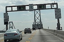
[10] Because of its height, the narrowness of the spans (there are no hard shoulders), the low guardrails, and the frequency of high winds, it is often cited as one of the scariest bridges in the United States.
[17] On August 10, 2008, a tractor trailer involved in a head-on collision near the west end fell from the bridge; the driver died in the crash.
[20] On June 24, 2024, traffic on both spans was suspended for nearly 30 minutes in late morning as the cargo ship MV Dali passed under, escorted by tugboats, on its journey from the Port of Baltimore to Virginia International Gateway in Norfolk, VA.
[21] With shore-to-shore lengths of 3.83 and 4.03 miles (6.16 and 6.49 km),[3][22] the two spans of the bridge form the longest fixed water crossing in Maryland.
[22] In 2006, pink markers were placed along the eastbound span to mark out the suggested following distance, similar to systems used in Minnesota and Pennsylvania.
The markers are a part of the MDTA's "Pace Your Space" campaign to prevent vehicle collisions and traffic congestion due to tailgating on the bridge.
[27][28] In April 2013, changes were made to increase safety on the westbound span during two-way operations: signs, pavement markings, and rumble strips were modified, and a buffer zone between the left and center lanes was created.
[33][34] The MDTA has used traffic cones and barrels to open and close crossovers, and to create tapers for the reversible lane.
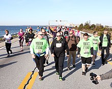
Participants started on the east end of the bridge (on Kent Island) and proceeded west to the finish near the toll plaza.
WMATA and MTA transit buses transported participants between outlying parking areas and the start and finish points.
It is conducted by the Annapolis Striders, a local running organization, and controlled by the MDTA and Maryland Department of Natural Resources.
[53] After increasingly consistent cancellations of the walking event, the MDTA, along with Queen Anne's County, contracted with an outside company to have a professional 10K race across the bridge, which has been labeled the "Across the Bay 10K".
When the bridge opened in 1952, and again when the second span was added in 1973, the Eastern Shore was given easier access to Baltimore and Washington, causing areas in southern Queen Anne's County to develop as bedroom communities.
During the 1950s, US 50 on the Western Shore was rerouted onto the long-proposed Annapolis–Washington Expressway (now known as the John Hanson Highway), which was built at the time in order to provide better access to the bridge.
Additionally, the road has been upgraded and realigned over the years from its original two-lane configuration to a four-lane divided highway, with the last such section being in Vienna, bypassed in 1991.
[63] Previous plans to expand US 50's freeway portion and replace the aging Harry W. Kelley Memorial Bridge into Ocean City have been delayed.
The following year, a task force formed by Governor Bob Ehrlich met to again explore the possibility of establishing a new Chesapeake Bay crossing.
Significant environmental and economic impacts were identified, with a report stating that any additional crossing is "expected to be multiple billions of dollars.