Chesil Beach
Owners of the land designated as Chesil & The Fleet SSSI[3] include the Crown Estate, the Ministry of Defence and the National Trust.
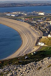
The beach provides shelter from the prevailing winds and waves for the town of Weymouth, Dorset and the village of Chiswell on Portland.
Simon Jenkins rates the view of Chesil Beach from Abbotsbury along the coast to Portland Bill as one of the top ten in England.
[8] Originally it was believed that beach material was from the Budleigh Salterton pebble beds to the west and later from Portland to the south east.
Normally, tombolos are created due to the effects of the island on waves (through refraction) and to sediment transport, which usually produces a beach perpendicular to the mainland rather than parallel to it.
A ship coming up the Channel had to clear Portland Bill to be safe, but the wind and tide would be pushing it northwards into Lyme Bay.
[9] When sailing ships were common, a strong string of coastguards were based along the beach, with lookouts and cottages at Chiswell, Wyke Regis, Chickerell, Langton Herring, Abbotsbury, East Bexington, Burton Bradstock and West Bay.
At present there are no manned Coastguard lookouts along the beach, with coverage provided when required from the National Maritime Operations Centre based at Fareham.
The local fishermen, particularly at Portland, developed a purpose-built vessel to withstand the sea actions of Chesil Beach.
Over the last 150 years there have been a number of proposals to build a line from Weymouth to Bridport running the length of Chesil Beach.
[12] The Royal Navy operated a minesweeping trials range off West Bexington for many years following World War II.
[10] The beach and the Fleet were used as an experimental bombing range by the RAF before and during World War II because of the low population density of nearby areas, as well as their proximity to the naval base on Portland.
[15] An observation post still exists on the landward side of the Fleet, with the open front facing Chesil Beach.
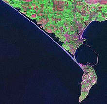
At Cliff End a hollow forms behind the beach and at Abbotsbury a stretch of saline (or brackish) water called the Fleet Lagoon begins.
[19] The lagoon is a designated bass nursery area, and the species are frequently seen on an underwater camera connected to the Chesil Beach Visitor Centre.
The Bridging Camp's inner training area allows Sappers to hone their skills on everything from raft building to familiarising themselves with state of the art weaponry.
[12] At Seabarn, a 68-metre-high (223 ft) hill located in the mid-Fleet, between Butterstreet Cove and Herbury, is a disused control tower and landing pad for the navy helicopter firing range in Lyme Bay.
[22] Due to the bird nesting season from 1 April until the end of August, access along, and to all parts of the beach from the Portland boundary stone to Abbotsbury is not permitted.
Additionally access to the Fleet slope of the beach from Wyke to Abbotsbury is not permitted at any time in effort to protect and conserve the delicate environment.
These species both grow submerged in the shallow waters of the mid and upper Fleet, where large quantities die off in the early autumn.
[23] Chesil Beach is a popular location for sea angling, with access at Chiswell, Ferry Bridge, Abbotsbury, Cogden, Burton Bradstock and West Bay.
Commercial fishing, which often involved seine nets, has now virtually disappeared from Chesil Beach compared with the level of activity a century ago.