Geology of Dorset
Covering an area of 2,653 square kilometres (1,024 sq mi); it borders Devon to the west, Somerset to the north-west, Wiltshire to the north-east, and Hampshire to the east.
[7][8] About 380 Mya, the landmass that was later to form Southern Britain was some 19° south of the equator and lay on the northern shore of an ocean basin that separated the continents of Laurasia and Gondwanaland.
When these continents collided to form the single supercontinent of Pangaea, the sediments on the ocean floor were pushed up and over, while the molten rock below the surface was forced out.
[9] Today, these igneous intrusions and the red sandstones, visible in the neighbouring county of Devon, slope away from west to east, and are deeply buried beneath younger deposits in Dorset.
[10] Through most of this period, southern Britain experienced continental conditions, initially with deposition by large river systems forming the Sherwood Sandstone Group.
The sides of the vale are mainly made from the clays and sands of the upper and lower Lias, while younger strata from the Cretaceous Period (145–66 Mya), crown the higher points.
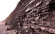
[22] The remaining part of the upper Lias is the bright yellow Bridport sandstone of Toarcian age, which gives the cliffs between West Bay and Burton Bradstock their distinctive colour.
[24] It contains many fossils, including bryozoans, brachiopods, ammonites, belemnites, gastropods, bivalves, and echinoids, and like the previous middle and upper Lias, shows signs of fault-controlled deposition.
One particular bed, exposed at Burton Cliff, contains large numbers of orange, discus-shaped concretions, which on closer inspection reveal themselves to be pieces of shell from a species of mussel, coated with a thin layer of iron-rich sediment.
[26] Despite being formed in a marine environment, the oolite, like the lower Lias, contains some fossilised remains of land-dwelling creatures, including two species of Megalosaurus that were found near Sherborne.
[26] Fuller's Earth Formation clays were deposited across much of southern Dorset when the continental shelf subsided, forcing the region deeper underwater during the early Bathonian.
[29] Outcrops of Forest Marble are concentrated around the Weymouth Anticline, the coastal escarpment between Burton Bradstock and Abbotsbury, and inland as far as Bothenhampton, where they disappear below younger Cretaceous deposits.
[30] The formation of the Forest Marble suggests a shallowing of the sea and the remains of pieces of tree, and bits of land-dwelling animals, are found among the turtles, frogs, and salamanders within.
In the north of the county, an already lithified Cornbrash floor was being eroded, and the resulting pebbles gathered serpulid worms, bryozoans, and bivalves as they rolled around beneath the shallow sea.
[33] Poor exposure, coupled with a decline in the brick industry, has made detailed mapping of the clays difficult, and now relies heavily on trenches dug for services.
In the following 4.5 million years, a cycle of lagoonal, tidal, and deep-water environments caused by a world-wide fluctuations in sea levels, deposited beds of sand, clay, and limestone across the entire county.
[38] Whether the formations created between the Upper Jurassic and Lower Cretaceous were deposited across the whole of Dorset like the preceding beds, and subsequently eroded, or only formed in the areas in which they are now found is unclear.
[40] The marine algae, which formed large reefs, are responsible for the occasional stacked and arched bands in the formation and are best viewed in the Roach, an extremely fossiliferous limestone confined to the north of Isle of Portland.
The climate around this time had changed from a tropical to a subtropical one, with pronounced wet and dry seasons as indicated by the growth rings in the fossilised trees also found in the lower levels of the Purbeck strata.
[47] The Purbeck Limestone Group has yielded a diverse selection of fossilised remains, including rare reptiles, amphibians, and mammals, for which the formation has become internationally important.
[49] By the latest part of the Berriasian, the waters covering Dorset's landmass had subsided, leaving the area almost completely terrestrial save for the large rivers that dominated it.
A much wider strip continues westward along the coast until it meets the wide swathe of chalk that cuts north-west across the county and forms the south-east point of the Hampshire Basin.
[62] In the east of the county, however, fossilised remains of gastropods and sharks' teeth have been found alongside flint pebbles, clearly identifying these clays as marine deposits.
[65] The fine particles that make up the clay are believed to have originated in the west, where rocks were being broken down by the alternating dry, humid conditions and torrential rain, which in turn formed rivers and carried the material to its current position.
[68] Mainly terrestrial with fresh and brackish water environments, the county, despite its low-lying nature, remained largely without marine influences except for some minor incursions at the end of the ice ages.
The late Palaeogene deposits that filled the Hampshire Basin as the sea levels fell are not found in Dorset, nor are the Neogene, which are absent from virtually all of the British Isles.
[69] Further, but less dramatic folding and uplift, along the county's subsurface faults, coupled with continuing erosion of Jurassic and Cretaceous sediments, created Dorset's modern landscape and drainage patterns.
[74] During the summers, partial melting of the ice created large rivers that washed enormous amounts of sand and gravel across the county, forming huge terraces in both the upland areas and valleys.
[75] Chesil Bank, a 29 kilometres (18 mi) long barrier beach stretching from West Bay to Portland, was created 10,000 years ago, when sea levels rose at the end of the last ice age.
[77] This major west–to-east-trending, south-dipping normal fault was mainly active during the late Jurassic to early Cretaceous, as shown by the local preservation of the Wealden in its hanging wall.