Chesters Bridge
[1] The bridge carried the Military Way Roman road behind the wall across the River North Tyne at this point, and was defended by the adjacent cavalry fort at its foundation, later given over to infantry.
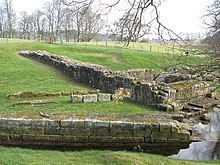
It crossed the river on a series of at least eight hexagonal stone piers about 13 feet (4 m) apart: the first of these (from the east) can be seen where it has been incorporated into the stonework of the later abutment.
The masonry appears to have been plain but substantial, and the surviving hexagonal pier bears traces of dovetail cramps of iron set in lead which would have held the stones tightly together.
This abutment, its massive rectangular stones lifted into place using the lewis holes which are a feature of their upper surface, were held together with long iron ties channelled into the masonry to reinforce the front face.
[2] From this solid abutment there sprang an elegant bridge with four arches supported on three substantial river piers, 34 feet (10.4 m) apart.
In the early 19th century Nathaniel Clayton, owner of Chesters House and Estate, moved hundreds of tons of earth to cover over the last remains of the fort as part of his parkland landscaping, thereby creating a smooth uninterrupted grassland slope down to the River Tyne; he collected, before they disappeared, a number of Roman artefacts which he preserved in the family.
However his son John Clayton, a noted antiquarian, removed all his father's work, exposing the fort, excavating, and establishing a small museum for his finds.