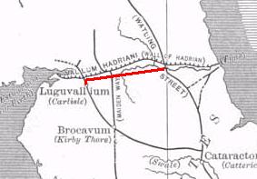
Luguvalium
[4] The name apparently continued in use among Brythonic speakers in the Hen Ogledd and Wales and it was during that time that the initial element caer ("fort") was added.
Following their earlier conquest of the southern part of Britain, and Boudica's revolt, the Roman armies began to conquer the north and erected a timber fort around 72 AD at a key point south of the River Eden in a loop protected on two sides by water, on the site of the later Carlisle Castle.
The fort was built by a vexillation of the legion Legio IX Hispana during the final campaign of Cerialis against the Brigantian Venutius.
[8] The fort was refurbished in 83 using oak timbers from further afield, rather than local alder,[9] indicating the greater Roman control of the area, and was garrisoned by a 500-strong cavalry regiment, the Ala Gallorum Sebosiana.
Coins excavated in the area suggest that Romans remained in Carlisle until the reign of Emperor Valentinian II, from 375 to 392.
[5] Saint Cuthbert visited the town in the 7th century and, according to Bede, described the high stone walls and an impressive fountain, presumably fed by a still-functioning aqueduct.
Three large marching camps near to Carlisle at Plumpton Head, Crackenthorpe and Rey Cross have all been attributed to the campaigns of governor Cerialis and dated sometime around 72/73AD.
Excavations in 1981-84 and 1990 discovered around 50 wooden writing tablets within the Roman fort, containing unique evidence for the cavalry regiment, the ala Gallorum Sebosiana, and its consumption of barley, wheat and weapons.
In 2017 imperial baths larger than any found near Hadrian's Wall, and possibly belonging to a mansio were discovered just north of the River Eden in the cricket ground.
[23] Archaeological artefacts discovered in 2021 suggest that the Roman emperor Septimius Severus and his consort Julia Domna may have spent time in Luguvalium around AD 208-211, since engraved stone fragments dedicated to the empress were found, as well as the emperor's personal workshop-stamped tiles (Severus was campaigning in Scotland at the time).