Chota Nagpur Plateau
The fossil-rich sedimentary units host fossilized remains across a range of biota, such as angiosperm leaves, fruits, flowers, wood, and fish.
The north-eastern and southern faces are mostly abrupt; but to the west it narrows and descends slowly in the neighbourhood of Simaria and Jabra where it curves to the south and connects with the Ranchi Plateau through Tori pargana.
[10] The western portion of Hazaribagh plateau constitutes a broad watershed between the Damodar drainage on the south and the Lilajan and Mohana rivers on the north.
The highest hills in this area are called after the villages of Kasiatu, Hesatu and Hudu, and rise fronting the south 180 m (600 ft) above the general level of the plateau.
Further east along the southern face a long spur projects right up to the Damodar river where it ends in Aswa Pahar, elevation 751 metres (2,465 ft).
Eastward this northern edge forms a well-defined watershed between heads of the tributaries of Gaya and those of the Barakar River, which traverses the Koderma and Giridih districts in an easterly direction.
The slope of this plateau to the east is uniform and gentle and is continued past the river, which bears to the south-east, into the Santhal Parganas and gradually disappears in the lower plains of Bengal.
[13] The Damodar basin forms a trough between the Ranchi and Hazaribagh plateaus resulting from enormous fractures at their present edges, which caused the land between to sink to a great depth and incidentally preserved from denudation by the Karanpura, Ramgarh and Bokaro coalfields.
Further to the east the Damodar River passes tamely into the Manbhum sector of lowest step of the Chota Nagpur plateau.
The general system of the area is a series of parallel ranges of hills running east and west through which the North Koel River passes.
Lodh Falls drops from a height of 150 metres (490 ft) from these hills, making it the highest waterfall on the Chota Nagpur Plateau.
[22] The Chota Nagpur Plateau receives an annual average rainfall of around 1,400 millimetres (55 in), which is less than the rainforested areas of much of India and almost all of it in the monsoon months between June and August.
[5] The flora of the Chota Nagpur Plateau ranges from dry to wet forests, with trees reaching heights of up to 25 metres (82 ft).
Key species include sal (Shorea robusta), which provides valuable timber and supports diverse wildlife, and mahua (Madhuca longifolia), known for its fragrant flowers used to make a traditional alcoholic beverage and as a food source for animals.
Other significant plants include bamboo (Bambusa), teak (Tectona grandis),and wild mango (Mangifera indica), flame of the forest (Butea monosperma).
[24] The region is home to diverse wildlife, including apex predators like the tiger (Panthera tigris) and large herbivores such as the Asian elephant (Elephas maximus).
Ungulates such as the four-horned antelope (Tetracerus quadricornis), blackbuck (Antilope cervicapra), and chinkara (Gazella bennettii) are also common, alongside predators like the dhole (Cuon alpinus) and the sloth bear (Melursus ursinus).
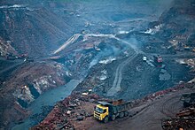
Mining for minerals like coal, iron ore, and bauxite has led to large-scale deforestation, soil erosion, and habitat fragmentation, which critically affects the survival and movement of native wildlife, particularly larger species such as elephants, tigers, and leopards that require extensive, undisturbed areas.
Some conservation efforts are underway, including the establishment of protected areas and wildlife corridors[26]aimed at reconnecting fragmented habitats.
However, challenges remain due to limited enforcement of conservation policies and the economic dependence of local communities on mining and agriculture, which places continual pressure on the plateau’s ecological resources.
[27] The Chota Nagpur region is a culturally rich area with a diverse population comprising various indigenous ethinic group of Sadan and tribes.
Festivals like Sarhul, Holi and Karam are central to their culture, celebrating harvests and nature with traditional music, dance, and rituals.
[29][30][31] Stone tools from the Chota Nagpur Plateau indicate human activity dating back to the Mesolithic and Neolithic periods.
Large-scale extraction industries in coal and iron mining dominate the economy, alongside growing steel production, power generation, and related infrastructure developments.
Chota Nagpur plateau is a store house of mineral resources such as mica, bauxite, copper, limestone, iron ore and coal.